IMAGES TAKEN NEAR TO
Wakefield Road, BRIGHOUSE, HD6 4HA
Introduction
This page details the photographs taken nearby to Wakefield Road, HD6 4HA by members of the Geograph project.
The Geograph project started in 2005 with the aim of publishing, organising and preserving representative images for every square kilometre of Great Britain, Ireland and the Isle of Man.

There are currently over 7.5m images from over14,400 individuals and you can help contribute to the project by visiting https://www.geograph.org.uk
Image Map
Images are licensed for reuse under creativecommons.org/licenses/by-sa/2.0
Notes
- Clicking on the map will re-center to the selected point.
- The higher the marker number, the further away the image location is from the centre of the postcode.
Image Listing (40 Images Found)
Images are licensed for reuse under creativecommons.org/licenses/by-sa/2.0
Image
Details
Distance
1
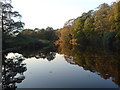
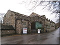
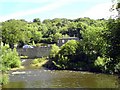
Kirklees Mill
A Grade II Listed former water mill from the late 18th century. Now The Old Mill public house.
Image: © Chris Allen
Taken: 6 May 2023
0.01 miles
2
The Old Mill public house
This is the former Kirklees Mill that is a Grade II Listed former watermill on the River Calder.
Image: © Chris Allen
Taken: 6 May 2023
0.01 miles
3
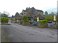
The Old Mill, Wakefield Road, Brighouse
I used to come here occasionally in the 1990s when it was a more upmarket restaurant called the Corn Mill, but it seems to have had its present name for at least ten years Image and is now a run-of-the-mill Greene King pub (please excuse the pun). The building is of architectural interest, being listed grade II (list entry 1184463) and described as an 18th century corn mill. The weir that fed it with water power is still extant Image
Image: © Stephen Craven
Taken: 5 Nov 2022
0.01 miles
4
Motel by the River Calder
The river is immediately to the right.
Image: © Jonathan Thacker
Taken: 19 Nov 2012
0.02 miles
5
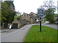
The Old Mill
A large public house.
Image: © Jonathan Thacker
Taken: 19 Nov 2012
0.02 miles
6
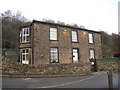
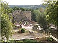
Mill House
Part of a small former mill complex.
Image: © Jonathan Thacker
Taken: 19 Nov 2012
0.02 miles
7
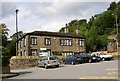
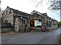
Mill Cottage, Clifton
This building was associated with the corn mill to the left of the picture. It has recently become a Montessori school.
Image: © Humphrey Bolton
Taken: 19 Sep 2005
0.03 miles
8
Mill Cottage Montessori School
View of the school across the River Calder taken from the ait between the Calder and Hebble Canal and the River Calder.
Image: © Tim Marchant
Taken: 1 Jul 2008
0.03 miles
9
The Old Corn Mill, Clifton
The Old Corn Mill (now a pub-restaurant-night club) is described as 'the old mill' in the charter during the reign of Henry II (1154-1189) granting land for Kirklees Priory. By late 19C it was also used by the Brearley family for cloth-fulling. The Dean family then ran the mill for 70 years, followed by the Fairburns (wire-drawing and card making). There were at one time two wheels, one for corn and one for fulling (later replaced by a turbine).
Image: © Humphrey Bolton
Taken: 19 Sep 2005
0.03 miles