IMAGES TAKEN NEAR TO
Winding Rise, BRIGHOUSE, HD6 4FS
Introduction
This page details the photographs taken nearby to Winding Rise, HD6 4FS by members of the Geograph project.
The Geograph project started in 2005 with the aim of publishing, organising and preserving representative images for every square kilometre of Great Britain, Ireland and the Isle of Man.

There are currently over 7.5m images from over14,400 individuals and you can help contribute to the project by visiting https://www.geograph.org.uk
Image Map
Images are licensed for reuse under creativecommons.org/licenses/by-sa/2.0
Notes
- Clicking on the map will re-center to the selected point.
- The higher the marker number, the further away the image location is from the centre of the postcode.
Image Listing (153 Images Found)
Images are licensed for reuse under creativecommons.org/licenses/by-sa/2.0
Image
Details
Distance
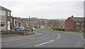
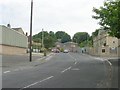
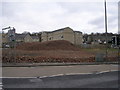
3
Axminster Drive - Wyke Old Lane, Bailiff Bridge
Image: © Betty Longbottom
Taken: 19 Apr 2008
0.06 miles
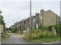
4
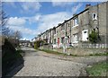
Booth's Buildings, Bailiff Bridge
Back-to back houses along Field Top, off Wyke Old Lane.
Image: © Humphrey Bolton
Taken: 1 Apr 2010
0.06 miles
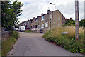
5
Building on the corner of Wyke Old Lane and Bradford Road
Image: © Alexander P Kapp
Taken: 27 Oct 2008
0.07 miles
6
Firth's Carpets - viewed from Wyke Old Lane, Bailiff Bridge
Image: © Betty Longbottom
Taken: 19 Apr 2008
0.07 miles
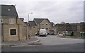
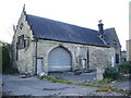
8
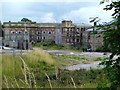
Disused Mill At Bailiff Bridge
Premises formerly used by Firth Carpets, now derelict and awaiting redevelopment.
Image: © Tim Marchant
Taken: 3 Aug 2008
0.07 miles
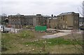
9
All that remains of Firth's Carpet Mill! - Bradford Road
Image: © Betty Longbottom
Taken: 8 Feb 2010
0.07 miles