IMAGES TAKEN NEAR TO
North Vale Court, BRIGHOUSE, HD6 4FL
Introduction
This page details the photographs taken nearby to North Vale Court, HD6 4FL by members of the Geograph project.
The Geograph project started in 2005 with the aim of publishing, organising and preserving representative images for every square kilometre of Great Britain, Ireland and the Isle of Man.

There are currently over 7.5m images from over14,400 individuals and you can help contribute to the project by visiting https://www.geograph.org.uk
Image Map
Images are licensed for reuse under creativecommons.org/licenses/by-sa/2.0
Notes
- Clicking on the map will re-center to the selected point.
- The higher the marker number, the further away the image location is from the centre of the postcode.
Image Listing (153 Images Found)
Images are licensed for reuse under creativecommons.org/licenses/by-sa/2.0
Image
Details
Distance
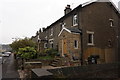
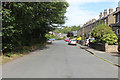
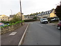
4
Birkhouse Road, Clifton
Terrace houses probably built for workers in the mills down in the valley.
Image: © Humphrey Bolton
Taken: 9 Oct 2006
0.03 miles
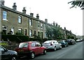
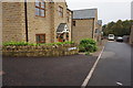
5
Birkhouse Road, Bailiff Bridge
Adopted by the Calderdale Way long distance footpath, seen here heading towards Birkby Lane, the A649
Image: © Chris Heaton
Taken: 29 Aug 2018
0.03 miles

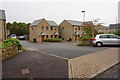
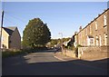
10
Birkhouse Lane meeting Birkby Lane in Bailiff Bridge
Looking northward.
Image: © Peter Wood
Taken: 5 Oct 2014
0.06 miles