IMAGES TAKEN NEAR TO
Highfield Avenue, BRIGHOUSE, HD6 4EB
Introduction
This page details the photographs taken nearby to Highfield Avenue, HD6 4EB by members of the Geograph project.
The Geograph project started in 2005 with the aim of publishing, organising and preserving representative images for every square kilometre of Great Britain, Ireland and the Isle of Man.

There are currently over 7.5m images from over14,400 individuals and you can help contribute to the project by visiting https://www.geograph.org.uk
Image Map
Images are licensed for reuse under creativecommons.org/licenses/by-sa/2.0
Notes
- Clicking on the map will re-center to the selected point.
- The higher the marker number, the further away the image location is from the centre of the postcode.
Image Listing (161 Images Found)
Images are licensed for reuse under creativecommons.org/licenses/by-sa/2.0
Image
Details
Distance
1
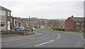
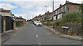
Royds Avenue, Bailiff Bridge
The continuous roof along the front of the houses covers bay windows and gives shelter in front of the doors.
Image: © Humphrey Bolton
Taken: 1 Apr 2010
0.00 miles
5
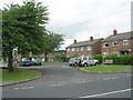
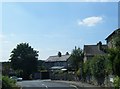
Lower Wyke Lane - off Wyke Old Lane
Image: © Betty Longbottom
Taken: 4 Jul 2009
0.05 miles
7
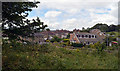
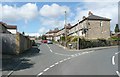
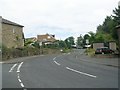
View from a disused railway line near Lower Wyke Lane, Bailiff Bridge
Image: © habiloid
Taken: 26 Jul 2020
0.06 miles
8

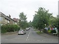
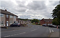
Ordnance Survey Cut Mark
This mark can be found on the wall of a house in Highfield Avenue.
For more detail see : http://www.bench-marks.org.uk/bm43965
Image: © Peter Wood
Taken: 15 Jul 2012
0.06 miles