IMAGES TAKEN NEAR TO
Rayner Road, BRIGHOUSE, HD6 4AY
Introduction
This page details the photographs taken nearby to Rayner Road, HD6 4AY by members of the Geograph project.
The Geograph project started in 2005 with the aim of publishing, organising and preserving representative images for every square kilometre of Great Britain, Ireland and the Isle of Man.

There are currently over 7.5m images from over14,400 individuals and you can help contribute to the project by visiting https://www.geograph.org.uk
Image Map
Images are licensed for reuse under creativecommons.org/licenses/by-sa/2.0
Notes
- Clicking on the map will re-center to the selected point.
- The higher the marker number, the further away the image location is from the centre of the postcode.
Image Listing (239 Images Found)
Images are licensed for reuse under creativecommons.org/licenses/by-sa/2.0
Image
Details
Distance
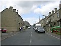
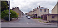
3
The Martin's Nest, Bradford Road, Brighouse
Between Smithy Carr Lane and Cross Street.
Image: © Humphrey Bolton
Taken: 30 Oct 2007
0.01 miles
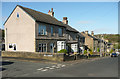
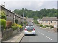
5
Rayner Road, Brighouse
Bradford Road (A641) runs across the foreground.
Image: © habiloid
Taken: 26 Jul 2020
0.01 miles

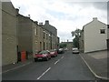
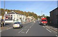
10
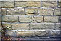
Benchmark on #140 Bradford Road
Ordnance Survey cut mark benchmark described on the Bench Mark Database at www.bench-marks.org.uk/bm49302
Image: © Roger Templeman
Taken: 27 Jul 2018
0.05 miles