IMAGES TAKEN NEAR TO
Woodvale Road, BRIGHOUSE, HD6 4AX
Introduction
This page details the photographs taken nearby to Woodvale Road, HD6 4AX by members of the Geograph project.
The Geograph project started in 2005 with the aim of publishing, organising and preserving representative images for every square kilometre of Great Britain, Ireland and the Isle of Man.

There are currently over 7.5m images from over14,400 individuals and you can help contribute to the project by visiting https://www.geograph.org.uk
Image Map
Images are licensed for reuse under creativecommons.org/licenses/by-sa/2.0
Notes
- Clicking on the map will re-center to the selected point.
- The higher the marker number, the further away the image location is from the centre of the postcode.
Image Listing (267 Images Found)
Images are licensed for reuse under creativecommons.org/licenses/by-sa/2.0
Image
Details
Distance
1
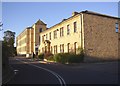
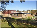
Woodvale Office Park, Brighouse
The photo shows refurbished old buildings, which first appeared on the 6" map of c.1895 as Woodvale Mill (a cotton mill on the 1907 map), but there are also a few modern buildings on the site.
Image: © Humphrey Bolton
Taken: 9 Oct 2006
0.02 miles
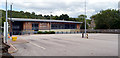
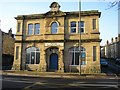
5
The police station, Bradford Road, Brighouse
Woodvale Mills are in the background
Image: © Humphrey Bolton
Taken: 30 Oct 2007
0.04 miles
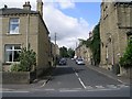
6
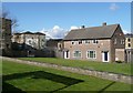
Houses next top the police station, Bradford Road, Brighouse
Perhaps built to house policemen, who can be on call for duty at short notice?.
Image: © Humphrey Bolton
Taken: 7 Apr 2008
0.04 miles
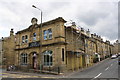
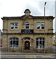
7
Brighouse Evangelical Church, Bradford Road
Built 1888 as the Brighouse & District Industrial Society Limited.
Image: © Stephen Armstrong
Taken: 11 Dec 2009
0.05 miles
8

Benchmark on Caf? 139, #139 Bradford Road
Ordnance Survey cut mark benchmark on the Industrial Street face of the building and described on the Bench Mark Database at www.bench-marks.org.uk/bm49289
Image: © Roger Templeman
Taken: 31 Jul 2018
0.05 miles
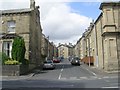
9
Caf? 139 (#139 Bradford Road) at Industrial Street junction
There is an OS benchmark Image on the right hand side of the building which has scaffolding erected along it. Café 139 is a community café run by Cornerstone Church.
Image: © Roger Templeman
Taken: 31 Jul 2018
0.05 miles
10
Caf? 139 (old Co-Op building) Bradford Road (A641), Brighouse
Image: © habiloid
Taken: 26 Jul 2020
0.05 miles