IMAGES TAKEN NEAR TO
Longroyde Grove, BRIGHOUSE, HD6 3US
Introduction
This page details the photographs taken nearby to Longroyde Grove, HD6 3US by members of the Geograph project.
The Geograph project started in 2005 with the aim of publishing, organising and preserving representative images for every square kilometre of Great Britain, Ireland and the Isle of Man.

There are currently over 7.5m images from over14,400 individuals and you can help contribute to the project by visiting https://www.geograph.org.uk
Image Map
Images are licensed for reuse under creativecommons.org/licenses/by-sa/2.0
Notes
- Clicking on the map will re-center to the selected point.
- The higher the marker number, the further away the image location is from the centre of the postcode.
Image Listing (131 Images Found)
Images are licensed for reuse under creativecommons.org/licenses/by-sa/2.0
Image
Details
Distance
1
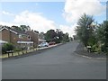
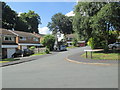
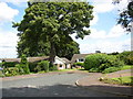
Field Top Road, Rastrick (SE137219)
This is the junction with Foxcroft Drive (East). The 20mph limit and one-way gates have been implemented because the road passes two schools. On the right is an area of grass and trees which thankfully has been left as an open space.
Image: © Humphrey Bolton
Taken: 4 Mar 2006
0.03 miles
2
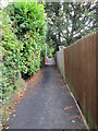
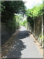
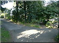
Footpath alongside Field Top Road, Rastrick (SE137219)
This was a narrow fenced path between fields (now built on) to the east (right) and the grounds of Rastrick House on the left.
Image: © Humphrey Bolton
Taken: 4 Mar 2006
0.03 miles
3
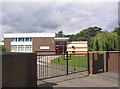
Castlefields Infants School, Field Top Road, Rastrick
A 'Community' school with children in Foundation, Year 1 and Year 2 classes from age 4 to 7. The last OFSTED report in 2002 stated that 'Castlefields is a very good school'.
Image: © Humphrey Bolton
Taken: 22 Jul 2007
0.03 miles
6
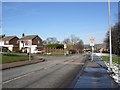
Brighouse FP88 at Castlefields Road, Rastrick
On the left you can see the broad grass verge of Field Top Road, part of what was a field.
Image: © Humphrey Bolton
Taken: 10 Sep 2015
0.04 miles
7
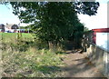
Bottom end of Wood View, Rastrick
A footpath goes off to the left. This appears from the 1940s 6” map to perpetuate a path northwards from the end of Field Lane, although perhaps not on the original line.
Image: © Humphrey Bolton
Taken: 22 Jul 2007
0.06 miles
8
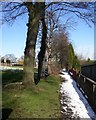
Brighouse FP88 at Field Lane, Rastrick
Field Lane goes to the left, to meet Field Top Road, and what was originally a field path carries straight on. It is now shaded by trees, and instead of a field there is a very broad grass verge.
Image: © Humphrey Bolton
Taken: 10 Sep 2015
0.06 miles