IMAGES TAKEN NEAR TO
Shepherds Thorn Lane, BRIGHOUSE, HD6 3TT
Introduction
This page details the photographs taken nearby to Shepherds Thorn Lane, HD6 3TT by members of the Geograph project.
The Geograph project started in 2005 with the aim of publishing, organising and preserving representative images for every square kilometre of Great Britain, Ireland and the Isle of Man.

There are currently over 7.5m images from over14,400 individuals and you can help contribute to the project by visiting https://www.geograph.org.uk
Image Map
Images are licensed for reuse under creativecommons.org/licenses/by-sa/2.0
Notes
- Clicking on the map will re-center to the selected point.
- The higher the marker number, the further away the image location is from the centre of the postcode.
Image Listing (82 Images Found)
Images are licensed for reuse under creativecommons.org/licenses/by-sa/2.0
Image
Details
Distance
1
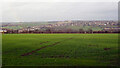
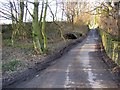
Looking north from Shepherds Thorn Lane, Brighouse
Image: © habiloid
Taken: 5 Feb 2022
0.04 miles
2
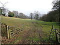
Part of the site for Brighouse Garden Suburb (SE corner)
This field may shortly become part of a proposed housing development called "Brighouse Garden Suburb" comprising 1257 properties on 62ha of land. Construction was planned to be phased from 2020-2033, although the 2020 Covid-19 pandemic seems to have delayed the start of construction.
Image: © Stephen Craven
Taken: 24 Dec 2020
0.05 miles
3
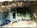
Remains of Throstle Nest, Shepherds Thorn Lane (detail)
Looking inside the structure seen in Image
Image: © Stephen Craven
Taken: 24 Dec 2020
0.05 miles
4
Remains of Throstle Nest, Shepherds Thorn Lane
Old maps show a farmhouse called Throstle Nest here. The only remaining structure seems to be this cellar - see also Image
Image: © Stephen Craven
Taken: 24 Dec 2020
0.05 miles
5
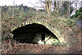
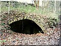
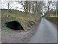
Ruin, Shepherds Thorn Lane, Brighouse
This structure (probably a cellar) is believed to be all that remains of Throstle Nest farmhouse. It be seen in context in Image
Image: © habiloid
Taken: 5 Feb 2022
0.05 miles
6
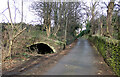
Ruin, Shepherds Thorn Lane, Brighouse
This structure (probably a cellar) is believed to be all that remains of Throstle Nest farmhouse. A close-up can be seen in Image
Image: © habiloid
Taken: 5 Feb 2022
0.05 miles
7
Shepherds Thorn Lane, Old Cellar
Remaining feature of an old building long gone
Image: © yorkshirelad
Taken: 10 Mar 2021
0.06 miles
8
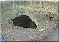
Vaulted cellar, Shepherds Thorn Lane, Rastrick
This is all that remains of Throstle Nest. There is a small recess in the back wall, possibly a cupboard.
Image: © Humphrey Bolton
Taken: 27 Jan 2007
0.06 miles
9
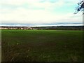
Site of Throstle Nest (?), Shepherds Thorn Lane, Rastrick
The mid-20C 6” map shows a building on the left and the caption 'Throstle Nest', although the 1850 map shows Throstle Nest as being down by Bradley Park Dike, SW of the photographer.
Image: © Humphrey Bolton
Taken: 27 Jan 2007
0.06 miles
10
A field by Shepherds Thorn Lane, Brighouse
Bradley Woods are on the right.
Image: © habiloid
Taken: 5 Feb 2022
0.06 miles