IMAGES TAKEN NEAR TO
Danebury Road, BRIGHOUSE, HD6 3TD
Introduction
This page details the photographs taken nearby to Danebury Road, HD6 3TD by members of the Geograph project.
The Geograph project started in 2005 with the aim of publishing, organising and preserving representative images for every square kilometre of Great Britain, Ireland and the Isle of Man.

There are currently over 7.5m images from over14,400 individuals and you can help contribute to the project by visiting https://www.geograph.org.uk
Image Map
Images are licensed for reuse under creativecommons.org/licenses/by-sa/2.0
Notes
- Clicking on the map will re-center to the selected point.
- The higher the marker number, the further away the image location is from the centre of the postcode.
Image Listing (108 Images Found)
Images are licensed for reuse under creativecommons.org/licenses/by-sa/2.0
Image
Details
Distance
1
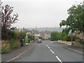
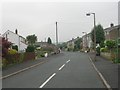
Green strip off Amport Close, Rastrick
One of three strips that connect parallel estate roads. It looks as if they were originally intended as roads.
Image: © Humphrey Bolton
Taken: 18 Mar 2009
0.04 miles
3
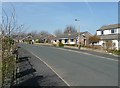
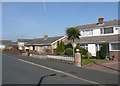
Stratton Road, Rastrick
This road runs around the northern edge of the Lower Newlands housing development. The steep slope above the railway is behind the bungalows.
Image: © Humphrey Bolton
Taken: 18 Mar 2009
0.07 miles
5
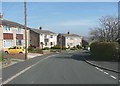
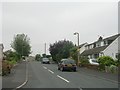
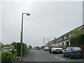
Danebury Road, Rastrick
Taken from the junction with Amport Close.
Image: © Humphrey Bolton
Taken: 18 Mar 2009
0.08 miles
6
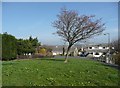
Amport Close, Rastrick
I can never resist photographing a suburban palm tree.
Image: © Humphrey Bolton
Taken: 18 Mar 2009
0.08 miles
10
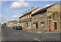
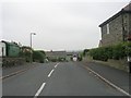
Birds Royd Lane, Rastrick
The view from the junction with Mission Street (named after the Wesleyan mission chapel). Although this is an industrial area, there are a number of 19C terrace houses here and there.
Image: © Humphrey Bolton
Taken: 12 Sep 2007
0.10 miles