IMAGES TAKEN NEAR TO
Stratton Road, BRIGHOUSE, HD6 3TA
Introduction
This page details the photographs taken nearby to Stratton Road, HD6 3TA by members of the Geograph project.
The Geograph project started in 2005 with the aim of publishing, organising and preserving representative images for every square kilometre of Great Britain, Ireland and the Isle of Man.

There are currently over 7.5m images from over14,400 individuals and you can help contribute to the project by visiting https://www.geograph.org.uk
Image Map
Images are licensed for reuse under creativecommons.org/licenses/by-sa/2.0
Notes
- Clicking on the map will re-center to the selected point.
- The higher the marker number, the further away the image location is from the centre of the postcode.
Image Listing (132 Images Found)
Images are licensed for reuse under creativecommons.org/licenses/by-sa/2.0
Image
Details
Distance
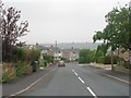
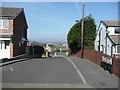
1
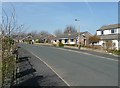
Stratton Road, Rastrick
This road runs around the northern edge of the Lower Newlands housing development. The steep slope above the railway is behind the bungalows.
Image: © Humphrey Bolton
Taken: 18 Mar 2009
0.03 miles
2
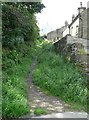
Old path off Lord's Lane, Rastrick
This used to branch off from Birds Royd Lane, before the railway was constructed and Lord's Lane was made. It led to some fields and a wood. Later it was the access to Fieldhead, the white house at the top, but presumably it has an alternative access now. It is a public footpath to Stratton Road.
Image: © Humphrey Bolton
Taken: 15 Aug 2008
0.04 miles
3
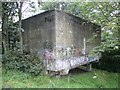
Concrete structure at the top of Dick Bank, Rastrick
I have been informed that this is a water tower built solely to fill the steam engines using a gravity feed system. There used to be two large iron pipes that led from the underside of the structure down the bank to the edge of the railway lines where it connected to a water crane.
Image: © Humphrey Bolton
Taken: 1 Sep 2008
0.04 miles
4
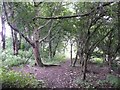
Secondary woodland in Yew Close, Rastrick
To the left (south-east) of the path shown in Image there was, in 1824, a field called Yew Close. By 1907 the eastern part of the field had been acquired by the railway company, who cut back the hillside to form the present steep bank, so that they could construct sidings. This view is of the southern part of the former field, next to the rear of the Stratton Road development.
Image: © Humphrey Bolton
Taken: 1 Sep 2008
0.04 miles
5
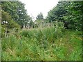
Yew Close, Rastrick
This central part of what is left of the field is grassland with brambles and rose-bay willowherb. There is a hairpin-shaped path, probably popular with people walking dogs.
Image: © Humphrey Bolton
Taken: 1 Sep 2008
0.04 miles
6
Orchard in Yew Close, Rastrick
The lower part of what is left of the field called Yew Close became a small-holding at some time; it was divided from the rest of the field by a dry-stone retaining wall. It seems derelict at present, but perhaps someone will pick the apples.
Image: © Humphrey Bolton
Taken: 1 Sep 2008
0.04 miles
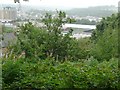
9
Stratton Park, Rastrick
The access road to a development down in the valley, squeezed between existing houses where there was once just a footpath. The former Friends' Meeting House off Huddersfield Road. can be seen in the distance.
Image: © Humphrey Bolton
Taken: 18 Mar 2009
0.08 miles
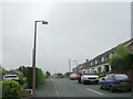
10
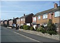
Stratton Road, Rastrick
Here there is a row of houses with tiled walls.
Image: © Humphrey Bolton
Taken: 18 Mar 2009
0.08 miles