IMAGES TAKEN NEAR TO
Armitage Avenue, BRIGHOUSE, HD6 3SP
Introduction
This page details the photographs taken nearby to Armitage Avenue, HD6 3SP by members of the Geograph project.
The Geograph project started in 2005 with the aim of publishing, organising and preserving representative images for every square kilometre of Great Britain, Ireland and the Isle of Man.

There are currently over 7.5m images from over14,400 individuals and you can help contribute to the project by visiting https://www.geograph.org.uk
Image Map
Images are licensed for reuse under creativecommons.org/licenses/by-sa/2.0
Notes
- Clicking on the map will re-center to the selected point.
- The higher the marker number, the further away the image location is from the centre of the postcode.
Image Listing (73 Images Found)
Images are licensed for reuse under creativecommons.org/licenses/by-sa/2.0
Image
Details
Distance
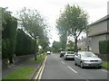
1
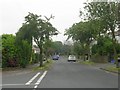
Armitage Avenue - viewed from Archbell Avenue
Image: © Betty Longbottom
Taken: 29 Jun 2009
0.02 miles

3
Shaftesbury Avenue - Long Fallas Crescent
Image: © Betty Longbottom
Taken: 29 Jun 2009
0.04 miles
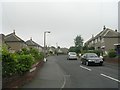
5

Post Office and Londis Store, Woodhouse Lane, Brighouse
Image: © habiloid
Taken: 19 Feb 2022
0.06 miles
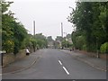
7
Armitage Avenue - Huddersfield Road
Image: © Betty Longbottom
Taken: 4 Jul 2009
0.07 miles
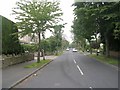
8
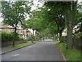
Woodhouse Lane - viewed from Armitage Avenue
Image: © Betty Longbottom
Taken: 29 Jun 2009
0.07 miles
9
Long Fallas Crescent - Woodhouse Lane
Image: © Betty Longbottom
Taken: 29 Jun 2009
0.07 miles
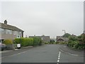
10

Woodhouse Lane, Brighouse, at its junction with Long Fallas Crescent
A close-up of the post box can be seen in Image
Image: © habiloid
Taken: 19 Feb 2022
0.08 miles