IMAGES TAKEN NEAR TO
Huddersfield Road, BRIGHOUSE, HD6 3RD
Introduction
This page details the photographs taken nearby to Huddersfield Road, HD6 3RD by members of the Geograph project.
The Geograph project started in 2005 with the aim of publishing, organising and preserving representative images for every square kilometre of Great Britain, Ireland and the Isle of Man.

There are currently over 7.5m images from over14,400 individuals and you can help contribute to the project by visiting https://www.geograph.org.uk
Image Map
Images are licensed for reuse under creativecommons.org/licenses/by-sa/2.0
Notes
- Clicking on the map will re-center to the selected point.
- The higher the marker number, the further away the image location is from the centre of the postcode.
Image Listing (265 Images Found)
Images are licensed for reuse under creativecommons.org/licenses/by-sa/2.0
Image
Details
Distance
1
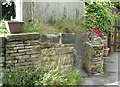
Stile on Brighouse FP91 at the back road parallel with Huddersfield Road, Rastrick
The stile has presumably been retained to deter cycling.
Image: © Humphrey Bolton
Taken: 8 Oct 2015
0.01 miles
2
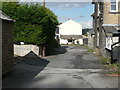
Brighouse FP91 on a back road parallel with Huddersfield Road, Rastrick
This is approaching the stile shown in Image
Image: © Humphrey Bolton
Taken: 8 Oct 2015
0.01 miles
3
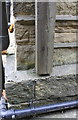
Benchmark on #35 Huddersfield Road
Ordnance Survey cut mark benchmark described on the Bench Mark Database at https://www.bench-marks.org.uk/bm41900
Image: © Roger Templeman
Taken: 24 Jul 2018
0.02 miles
4
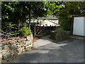
Brighouse FP91 leaving the driveway off Healey Wood Road, Rastrick
Image: © Humphrey Bolton
Taken: 8 Oct 2015
0.02 miles
5
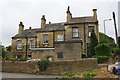
Nos. 31, 33 and 35 Huddersfield Road
There is an OS benchmark Image on the side of the right hand house at its front corner
Image: © Roger Templeman
Taken: 24 Jul 2018
0.03 miles
6
Brighouse FP91 on a driveway off Healey Wood Road, Rastrick
There isn't a signpost here, so you have to be confident and walk past the 'private road' signs.
Image: © Humphrey Bolton
Taken: 8 Oct 2015
0.03 miles
7
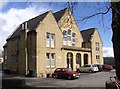
Former Friends' Meeting House, Huddersfield Road, Rastrick
This was built in 1868 to replace the one at Snake Hill (west end of Birds Royd Lane).
Image: © Humphrey Bolton
Taken: 8 Apr 2006
0.05 miles
8
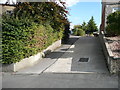
Bend in Healey Wood Lane, Rastrick
This is where the road descends steeply down an undeveloped hillside between the 20C suburb above and the 19C one below.
Image: © Humphrey Bolton
Taken: 8 Oct 2015
0.05 miles
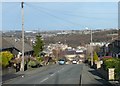
9
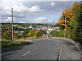
Healey Wood Road, Rastrick
At the bottom end of the housing estate the road drops steeply down to Aire Street.The detached house to the right of the lamp post has an unusual roof.
Image: © Humphrey Bolton
Taken: 17 Dec 2010
0.06 miles
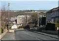
10
Healey Wood Road, Rastrick
This is the lower end of the housing estate. The road here is quite steep, but gets steeper further down - see Image
Image: © Humphrey Bolton
Taken: 17 Dec 2010
0.06 miles