IMAGES TAKEN NEAR TO
Aire Street, BRIGHOUSE, HD6 3RB
Introduction
This page details the photographs taken nearby to Aire Street, HD6 3RB by members of the Geograph project.
The Geograph project started in 2005 with the aim of publishing, organising and preserving representative images for every square kilometre of Great Britain, Ireland and the Isle of Man.

There are currently over 7.5m images from over14,400 individuals and you can help contribute to the project by visiting https://www.geograph.org.uk
Image Map
Images are licensed for reuse under creativecommons.org/licenses/by-sa/2.0
Notes
- Clicking on the map will re-center to the selected point.
- The higher the marker number, the further away the image location is from the centre of the postcode.
Image Listing (479 Images Found)
Images are licensed for reuse under creativecommons.org/licenses/by-sa/2.0
Image
Details
Distance
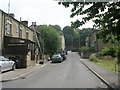
1
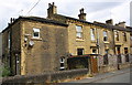
Houses on Aire Street at Victoria Street junction
There is an OS benchmark Image on the road end of the party wall (left of the brown trellis gate) between #12 Aire Street and #13 Victoria Street
Image: © Roger Templeman
Taken: 18 Jul 2018
0.02 miles
2
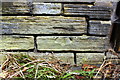
Benchmark on wall in front of #12 Aire Street
Ordnance Survey cut mark benchmark described on the Bench Mark Database at www.bench-marks.org.uk/bm80435
Image: © Roger Templeman
Taken: 18 Jul 2018
0.02 miles
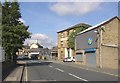
3
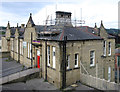
Brighouse - Youth Centre (E corner)
Image: © Dave Bevis
Taken: 1 Sep 2012
0.03 miles
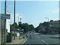
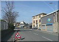
6
Birds Royd Lane, Rastrick
Approaching the junction with Huddersfield Road.
Image: © Humphrey Bolton
Taken: 12 Sep 2007
0.04 miles
7
Birds Royd Lane, Rastrick
Past the three-storey building there was a Friends' Meeting House and burial ground in the mid-19C.
Image: © Humphrey Bolton
Taken: 18 Mar 2009
0.04 miles
8
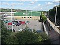
The station car park, Rastrick
This view is the result of holding the camera up over the high parapet wall at the northern end of the railway bridge and taking the photograph blind. I had not realised that the station platforms continue under the bridge, and that there is a ramp from a large car park. This area was formerly occupied by a large goods shed.
Image: © Humphrey Bolton
Taken: 30 Jul 2009
0.04 miles
9
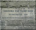
Datestone on the Huddersfield Road railway bridge, Rastrick
I was surprised that the district council had to undertake the reconstruction when the road was here before the railway. Perhaps it was part of a deal to get Brighouse station reopened?
Image: © Humphrey Bolton
Taken: 30 Jul 2009
0.04 miles
10
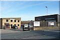
Impact and Chic, Birds Royd Lane, Rastrick
Princess Street is to the left of the Impact Repair Centre UK Ltd building, although it is no longer a public street.
Image: © Humphrey Bolton
Taken: 17 Dec 2010
0.04 miles