IMAGES TAKEN NEAR TO
Clough Lane, BRIGHOUSE, HD6 3QS
Introduction
This page details the photographs taken nearby to Clough Lane, HD6 3QS by members of the Geograph project.
The Geograph project started in 2005 with the aim of publishing, organising and preserving representative images for every square kilometre of Great Britain, Ireland and the Isle of Man.

There are currently over 7.5m images from over14,400 individuals and you can help contribute to the project by visiting https://www.geograph.org.uk
Image Map
Images are licensed for reuse under creativecommons.org/licenses/by-sa/2.0
Notes
- Clicking on the map will re-center to the selected point.
- The higher the marker number, the further away the image location is from the centre of the postcode.
Image Listing (188 Images Found)
Images are licensed for reuse under creativecommons.org/licenses/by-sa/2.0
Image
Details
Distance
1
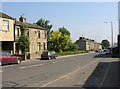
New Hey Road, Rastrick
This road was constructed around 1806, and was lined by ribbon development during the 19C. There were gaps between the terraces of houses, and in the one shown here there is a laburnum tree in flower. Below it is the track that leads to Badger Hill Cricket Ground.
Image: © Humphrey Bolton
Taken: 10 Jun 2006
0.00 miles
2
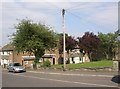
Regent Close and telephone pole, New North Road, Rastrick
Not a very good view of this little council housing estate, but the telephone pole has a remarkable number of wires radiating from it.
Image: © Humphrey Bolton
Taken: 6 Jun 2007
0.00 miles
3
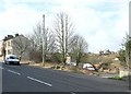
Entrance to cricket ground, New Hey Road, Rastrick
There is quite a large area of 'waste' ground' here, which must be valuable as a potential building site. Notice the skeleton of a seat.
Image: © Humphrey Bolton
Taken: 2 Mar 2008
0.00 miles
4
New Hey Road, Rastrick
Just above the 'waste' land near the entrance to the Badger Hill cricket ground. There is a through passage big enough for a cart, which led to a building at the rear. The house above the opening belonged to the Woods who had a haulage business. By the 1950s they were running motor taxis and lorries, which were stored in the yard through the passage in what was probably the stables for their horses and storage for wagons in their earlier history. The Woods Rolls Royce taxis were often used to transport the New Road Sunday School cricket team to away matches.
Image: © Humphrey Bolton
Taken: 18 Sep 2008
0.00 miles
5
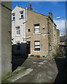
Houses, Fixby View Yard, Rastrick
These houses were built at about the same time as the houses with the deep eaves that front onto Clough Lane. The view of Fixby is blocked now.
Image: © Humphrey Bolton
Taken: 28 Feb 2017
0.00 miles
6
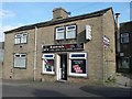
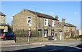
The former Black Horse Inn, now Rastrick Spice, New Hey Road
The inn existed in 1852, but closed in 1913, a victim of a campaign to reduce the number of public houses. A fish and chip shop followed, and lasted at least until 1939.
Image: © Humphrey Bolton
Taken: 31 Mar 2012
0.01 miles
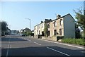
7
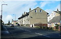
Houses with deep eaves, Clough Lane, Rastrick
These were built between 1893 and 1906 on 'Fletcher Lands'
Image: © Humphrey Bolton
Taken: 28 Feb 2017
0.02 miles
8
Regent Close, New Hey Road, Eastrick
A pleasant estate of small flats built around a lawn. It replaced rows of small cottages that were probably built for workers at the nearby Badger Hill Mills.
Image: © Humphrey Bolton
Taken: 28 Feb 2017
0.02 miles
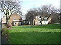
10
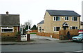
New houses, Clough Lane, Rastrick
There replaced a row of lock-up garages.
Image: © Humphrey Bolton
Taken: 24 Feb 2017
0.03 miles