IMAGES TAKEN NEAR TO
Dewsbury Road, BRIGHOUSE, HD6 3QD
Introduction
This page details the photographs taken nearby to Dewsbury Road, HD6 3QD by members of the Geograph project.
The Geograph project started in 2005 with the aim of publishing, organising and preserving representative images for every square kilometre of Great Britain, Ireland and the Isle of Man.

There are currently over 7.5m images from over14,400 individuals and you can help contribute to the project by visiting https://www.geograph.org.uk
Image Map
Images are licensed for reuse under creativecommons.org/licenses/by-sa/2.0
Notes
- Clicking on the map will re-center to the selected point.
- The higher the marker number, the further away the image location is from the centre of the postcode.
Image Listing (128 Images Found)
Images are licensed for reuse under creativecommons.org/licenses/by-sa/2.0
Image
Details
Distance
1
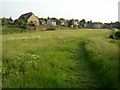
Southern end of Scar Edge, Elland
This is the only part of Scar Edge that looks to be used agriculturally, assuming that the grass is cut for hay. The buildings in the background are at Upper Edge, the chapel being the Baptist Chapel that faces Dewsbury Road. This is in Rastrick, the boundary being along the retaining wall. The path is a modern one, not marked on maps of 50 years ago and not a right-of-way.
Image: © Humphrey Bolton
Taken: 8 Jun 2006
0.01 miles
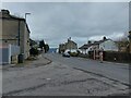
2
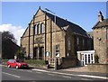
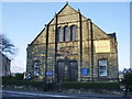
Baptist Chapel, Dewsbury Road, Rastrick
This chapel was opened in 1891 to serve the quarry-workers' settlement of Upper Edge.
Image: © Humphrey Bolton
Taken: 23 Sep 2006
0.01 miles
3
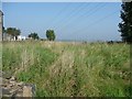
Part of Delf Close, Dewsbury Road B6114, Rastrick
This part of the field called Delf Close has not been built on, and I don't think it has been quarried. It seems to be neglected.
Image: © Humphrey Bolton
Taken: 18 Sep 2008
0.01 miles
5
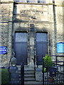
Baptist Church at Elland Upper Edge, Doorway
Image: © Alexander P Kapp
Taken: 27 Oct 2008
0.03 miles
6
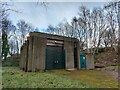
Unknown Yorkshire Water infrastructure, Pinfold Lane/Dewsbury Road
Image: © yorkshirelad
Taken: 21 Feb 2023
0.03 miles
7
Baptist Church at Elland Upper Edge
Image: © Alexander P Kapp
Taken: 27 Oct 2008
0.03 miles
8
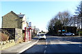
Bus stop and shelter on Dewsbury Road (B6114), Elland Upper Edge
Image: © JThomas
Taken: 6 Mar 2020
0.04 miles
9
Junction of Pinfold Lane and Dewsbury Road
Image: © yorkshirelad
Taken: 21 Feb 2023
0.05 miles
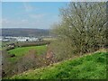
10
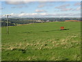
Field on the site of Five Acre Quarries, off Dewsbury Road, Rastrick
The quarries have been filled in and the land made into pasture. In the distance on the right is a spoil heap in the quarries that are still active.
Image: © Humphrey Bolton
Taken: 3 Sep 2006
0.05 miles