IMAGES TAKEN NEAR TO
Dewsbury Road, BRIGHOUSE, HD6 3QB
Introduction
This page details the photographs taken nearby to Dewsbury Road, HD6 3QB by members of the Geograph project.
The Geograph project started in 2005 with the aim of publishing, organising and preserving representative images for every square kilometre of Great Britain, Ireland and the Isle of Man.

There are currently over 7.5m images from over14,400 individuals and you can help contribute to the project by visiting https://www.geograph.org.uk
Image Map
Images are licensed for reuse under creativecommons.org/licenses/by-sa/2.0
Notes
- Clicking on the map will re-center to the selected point.
- The higher the marker number, the further away the image location is from the centre of the postcode.
Image Listing (106 Images Found)
Images are licensed for reuse under creativecommons.org/licenses/by-sa/2.0
Image
Details
Distance
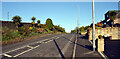
2
Old Quarry, Rastrick
These old quarries seem to lose their cliff faces and become grassy hollows. This one is in the middle of a hay meadow. The field is called Whinny Common on the 1824 township map and the quarry is shown as a sandstone quarry on the 1850 OS map.
Image: © Humphrey Bolton
Taken: 10 Jun 2006
0.03 miles
3
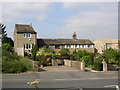
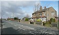
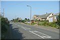
Houses, Dewsbury Road, Rastrick
In the centre is a row of three, and on the left a single three-storey house standing up like a tower. These were known by the locals as 'Cradle Cottages'. To its left is a public footpath leading to New North Road and Spout Hill. The house on the right was built recently. The photograph was taken from on top of the roadside bank, hence the flower in the foreground!
Image: © Humphrey Bolton
Taken: 6 Jun 2007
0.04 miles
4
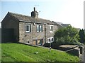
18C houses, Dewsbury Road B6114, Rastrick
A pair of 18C houses dated 1776, built by the Walker family who were quarry workers, presumably in the quarry that was immediately behind the houses on the edge of the old common. Members of the Walker family continued to own the house on the left house until 2001, when it was purchased by an architect, refurbished and modernised as invisibly as possible.
Image: © Humphrey Bolton
Taken: 18 Sep 2008
0.04 miles
5
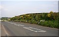
Roadside garden, Dewsbury Road, Rastrick
Here there is an embankment by the side of the road, which has been widened in the past. It has been made into a garden, probably by one or more of the people in the houses opposite.
Image: © Humphrey Bolton
Taken: 8 Jun 2006
0.06 miles
6
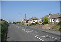
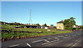
North side of Dewsbury Road, Rastrick
An old pair of semis, then the depôt of a haulage firm, with the cottages at Grantham in the distance
Image: © Humphrey Bolton
Taken: 2 Mar 2008
0.06 miles
7
Dewsbury Road B6114, Rastrick
This part of the road is in a cutting made perhaps as long ago as 1827 to reduce the gradient of the hill. The bungalows were in the 1950s.
Image: © Humphrey Bolton
Taken: 18 Sep 2008
0.06 miles
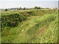
8
Top of Mowing Close, Dewsbury Road B6114, Rastrick
Mowing Close is a large field divided into four parts, the three nearest Dewsbury Road being considered to be the top end, although at the lower end as far as altitude is concerned.
Image: © Humphrey Bolton
Taken: 18 Sep 2008
0.06 miles
9
Dewsbury Road B6114, Rastrick
To the west of the 1950s bungalows there are two newer houses.
Image: © Humphrey Bolton
Taken: 18 Sep 2008
0.06 miles
10
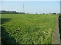
A field alongside Dewsbury Road (B6114), Rastrick
Image: © habiloid
Taken: 7 May 2022
0.06 miles