IMAGES TAKEN NEAR TO
Star Terrace, BRIGHOUSE, HD6 3NS
Introduction
This page details the photographs taken nearby to Star Terrace, HD6 3NS by members of the Geograph project.
The Geograph project started in 2005 with the aim of publishing, organising and preserving representative images for every square kilometre of Great Britain, Ireland and the Isle of Man.

There are currently over 7.5m images from over14,400 individuals and you can help contribute to the project by visiting https://www.geograph.org.uk
Image Map
Images are licensed for reuse under creativecommons.org/licenses/by-sa/2.0
Notes
- Clicking on the map will re-center to the selected point.
- The higher the marker number, the further away the image location is from the centre of the postcode.
Image Listing (233 Images Found)
Images are licensed for reuse under creativecommons.org/licenses/by-sa/2.0
Image
Details
Distance
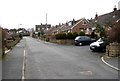
1
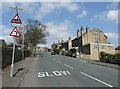
Lower Edge Road, Rastrick
Approaching the junction with Mayster Grove on the right and Highbury Special School on the left.
Image: © Humphrey Bolton
Taken: 20 Apr 2013
0.02 miles
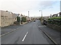
3
Mayster Grove seen from Lower Edge Road, Rastrick
Image: © habiloid
Taken: 7 May 2022
0.02 miles
4
Back lane behind Tofts Grove
This looks like a country lane, but gives access to the back gardens of the terrace houses at the top of Tofts Grove.
Image: © Humphrey Bolton
Taken: 12 Nov 2005
0.02 miles
5
Mayster Grove, Rastrick (SE134213)
This road started at the top, at Lower Edge Road, and has been extended in stages until it reached Field Lane. This is the top end, and the turning bay probably indicates its original extent.
Image: © Humphrey Bolton
Taken: 27 Feb 2006
0.02 miles
6
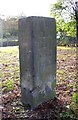
Guide Stone, Rastrick
This stands at the top of Tofts Grove at an ancient road junction. To the left up Delf Hill is to Huddersfield. To the right up Lower Edge Road is to Elland. Back down Tofts Grove is the Leeds and Bradford. There is the date 1787, at a time when townships were obliged to set up guideposts and important road junctions.
Image: © Humphrey Bolton
Taken: 12 Nov 2005
0.03 miles
7
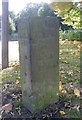
Old Guide Stone by Tofts Grove, Rastrick Parish
By the UC road, in parish of Rastrick (Calderdale District), just West of the A643 Crowtrees Lane. On grassy triangle at junction of Delf Hill with Tofts Grove.
Surveyed
Milestone Society National ID: YW_XRASa
Image: © Milestone Society
Taken: Unknown
0.03 miles
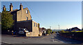
8
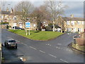
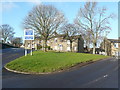
Grass triangle at the junction of Delf Hill, Lower Edge Road and Tofts Grove
This grass triangle is at a very old road junction. The road to the right is Tofts Grove, leading to the centre of Rastrick and down Rastrick Common to Brighouse Bridge, on the way to Leeds. To the left is Lower Edge Road, leading to Elland and onwards to Halifax or Rochdale. The road from Leeds to Rochdale is part of John Ogilby's road from York to Chester on Plate 89 of his road book 'Britannia', published in 1675. It became a turnpike road between Leeds and Elland c. 1740, and is shown as a main road on Thomas Jefferys's map of Yorkshire, 1775, which also shows the road in the foreground, Delf Hill. Delf Hill connects, via Slade Lane, to Clough Lane, which is the other old main road through Rastrick. Clough Lane is part of Ogilby's road from Barnsley to Richmond via Halifax and Skipton, on Plate 49 of Britannia, and later became the Dewsbury and Elland road, turnpiked c.1759.
The triangle of land, with a building on it, is shown on the Rastrick township map of 1824 and the 1850 six-inch map. The building is shown on 1:2500 maps up to the 1960s edition. Delf Hill, to the left of the triangle, was widened between the 1933 and 1960s editions. The road to the right was widened much earlier, between 1850 and 1894. The 1982 1:10000 map shows the whole triangle blank, so perhaps the building had been demolished by then. Until recently there was a bed of roses in the triangle, but this was grassed over during 2013, presumably part of the local government expenditure cuts.
Image: © Humphrey Bolton
Taken: 25 Dec 2013
0.03 miles
9
The grass triangle, Delf Hill
This is where Delf Hill meets Lower Edge Road to the left and Tofts Grove to the right. Long ago, before the road was widened, there was a house in the triangle. More recently there were rose beds, but presumably these were the victim of council expenditure cuts. This is a very old junction; there is an 18C guide stone by the lamp post in the right-hand corner.
Image: © Humphrey Bolton
Taken: 25 Dec 2014
0.03 miles
10
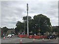
Phone Mast, Tofts Grove, Rastrick
Somewhat out of scale with the local environment, but we all need our phones!
Erected summer 2023.
Image: © Richard Kay
Taken: 23 Aug 2023
0.03 miles