IMAGES TAKEN NEAR TO
Delf Place, BRIGHOUSE, HD6 3NJ
Introduction
This page details the photographs taken nearby to Delf Place, HD6 3NJ by members of the Geograph project.
The Geograph project started in 2005 with the aim of publishing, organising and preserving representative images for every square kilometre of Great Britain, Ireland and the Isle of Man.

There are currently over 7.5m images from over14,400 individuals and you can help contribute to the project by visiting https://www.geograph.org.uk
Image Map
Images are licensed for reuse under creativecommons.org/licenses/by-sa/2.0
Notes
- Clicking on the map will re-center to the selected point.
- The higher the marker number, the further away the image location is from the centre of the postcode.
Image Listing (251 Images Found)
Images are licensed for reuse under creativecommons.org/licenses/by-sa/2.0
Image
Details
Distance
1
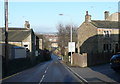
Delf Hill, looking down
A road that is too narrow for the amount of traffic using it, and with inadequate footways. Unfortunately there is no alternative route.
Image: © Humphrey Bolton
Taken: 25 Dec 2014
0.02 miles
2
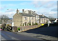
Houses on what was Delf Road, Rastrick
The first part of Delf Road is now the car park for The Greyhound. The remainder has been renamed Stonelea Drive with access from Crowtrees Lane.
These houses are on the 1824 township map, although the tallest house is obviously later, probably late 19C.
Image: © Humphrey Bolton
Taken: 28 Feb 2017
0.02 miles
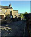
4
The junction of Delf Lane and Crowtrees Lane (A643), Rastrick
Image: © habiloid
Taken: 7 May 2022
0.02 miles
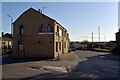
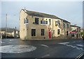
5
The Greyhound and the Sandwich Shop, Crowtrees Lane, Rastrick
This dates back to at least 1877, when it was owned by the brewers Joseph Shaw of Lindley. Later it was owned by Whitaker's brewery of Halifax.
Image: © Humphrey Bolton
Taken: 28 Feb 2017
0.02 miles
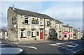
6
The Crow Bar & Kitchen (Greyhound Inn), Rastrick
This is apparently ready to open after extensive refurbishment of the building. I was pleased to see that the Greyhound Inn sign has been retained.
Image: © Humphrey Bolton
Taken: 25 Dec 2018
0.02 miles
7
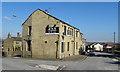
The Crow Bar & Kitchen, Rastrick
The former Greyhound Inn - Image]
Image: © JThomas
Taken: 6 Mar 2020
0.02 miles
8
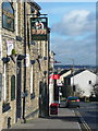
The Greyhound inn sign, Crowtrees Lane, Rastrick
Image: © Humphrey Bolton
Taken: 28 Feb 2017
0.03 miles
9
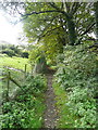
Footpath (Brighouse 103) from Delf Hill to Spout Hill
The path is looking quite rural here, although the grass on the left is a lawn, not pasture.
Image: © Humphrey Bolton
Taken: 26 Sep 2014
0.03 miles
10
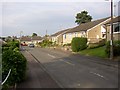
The Hoods, Rastrick
This is a development of bungalows in a field called Upper Hoods, off Delf Hill.
Image: © Humphrey Bolton
Taken: 12 Jun 2006
0.03 miles