IMAGES TAKEN NEAR TO
Carr Green Lane, BRIGHOUSE, HD6 3LT
Introduction
This page details the photographs taken nearby to Carr Green Lane, HD6 3LT by members of the Geograph project.
The Geograph project started in 2005 with the aim of publishing, organising and preserving representative images for every square kilometre of Great Britain, Ireland and the Isle of Man.

There are currently over 7.5m images from over14,400 individuals and you can help contribute to the project by visiting https://www.geograph.org.uk
Image Map
Images are licensed for reuse under creativecommons.org/licenses/by-sa/2.0
Notes
- Clicking on the map will re-center to the selected point.
- The higher the marker number, the further away the image location is from the centre of the postcode.
Image Listing (239 Images Found)
Images are licensed for reuse under creativecommons.org/licenses/by-sa/2.0
Image
Details
Distance
1

Rastrick Tennis Club, Carr Green Lane, Rastrick
The open courts are on the left, and the indoor courts are in the big shed. The large brick gable-end is relieved by decorative diamond shapes.
Image: © Humphrey Bolton
Taken: 12 Jun 2006
0.02 miles
2
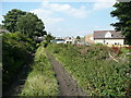
Brighouse FP99a, Rastrick
This view is looking towards Carr Green Lane. This track seems to have been a field access track, which was straightened and enclosed when the cemetery was made by Rastrick Local Board in the late 19C. The houses are being built on a triangular piece of land that was the site of the Carr Green Dyeworks (Woollen), which is on the 1850 six-inch map.
Image: © Humphrey Bolton
Taken: 10 Sep 2015
0.05 miles
3
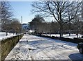
Carr Green Lane, Rastrick (SE138211)
This is an diversion of the original lane, and was probably built at the same time as the cemetery on the south (right-hand) of the road.
Image: © Humphrey Bolton
Taken: 4 Mar 2006
0.06 miles
4
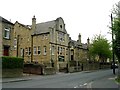
Carr Green Junior, Infants and Nursery School, Rastrick
A late 20C school replacing the one at the junction with Crowtrees Lane. It has over 350 pupils. It was built as a middle school in 1963, when the three-tier system was introduced.
Image: © Humphrey Bolton
Taken: 4 Mar 2006
0.06 miles
5
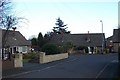
Oaks Green Mount, Rastrick
A quiet residential cul-de-sac off Crowtrees Lane. The houses were built in the late 1950s.
Image: © Richard Kay
Taken: 26 Feb 2008
0.06 miles
6
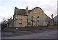
Carr Green nursing home, Rastrick
A former primary school dating from 1912: see also Image
Image: © Stephen Craven
Taken: 5 Jul 2014
0.06 miles
7
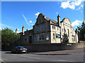
Former Carr Green Council School, Rastrick, Yorkshire
This photo is of the façade facing Crowtrees Lane. The school was built for 500 pupils in 1912, but has been replaced by a modern building down Carr Green Lane. The façade on the left, facing Carr Green Lane, has separate entrances for boys and girls. The building is now a residential and nursing home for 'older people'.
Image: © Humphrey Bolton
Taken: 17 Feb 2006
0.07 miles
8
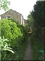
Footpath off Carr Green Lane
This is the bottom end of the footpath to Lower Fold.
Image: © Humphrey Bolton
Taken: 12 Jun 2006
0.07 miles
9
Carr Green Nursing Home - Carr Green Lane, Rastrick
This building was formerly a school.
Image: © Betty Longbottom
Taken: 14 May 2008
0.07 miles
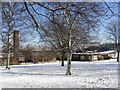
10
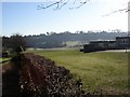
The back of Carr Green Lane School, Rastrick (SE138 212)
The hedge separates the school grounds from Ward Court, off Chapel Croft. In the distance there is a large area of playing fields, then the hillside up to Toothill.
Image: © Humphrey Bolton
Taken: 3 Mar 2006
0.07 miles