IMAGES TAKEN NEAR TO
Malham Road, BRIGHOUSE, HD6 3JZ
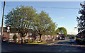
Introduction
This page details the photographs taken nearby to Malham Road, HD6 3JZ by members of the Geograph project.
The Geograph project started in 2005 with the aim of publishing, organising and preserving representative images for every square kilometre of Great Britain, Ireland and the Isle of Man.

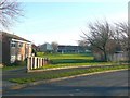
There are currently over 7.5m images from over14,400 individuals and you can help contribute to the project by visiting https://www.geograph.org.uk
Image Map
Images are licensed for reuse under creativecommons.org/licenses/by-sa/2.0
Notes
- Clicking on the map will re-center to the selected point.
- The higher the marker number, the further away the image location is from the centre of the postcode.
Image Listing (141 Images Found)
Images are licensed for reuse under creativecommons.org/licenses/by-sa/2.0
Image
Details
Distance
1
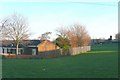
View from Arncliffe Crescent, Field Lane Estate, Rastrick
Arncliffe Crescent is staple-shaped, and at the eastern end there is a row of bungalows with a gap on each side leading into a play area.
Image: © Humphrey Bolton
Taken: 6 Jan 2009
0.03 miles
2
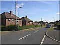
Malham Road, Rastrick
Looking from the junction with Nunnery Lane.
Image: © Humphrey Bolton
Taken: 18 Sep 2007
0.03 miles
3
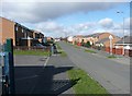
Burnsall Road, Rastrick
Looking past the entrance to a parking area.
Image: © Humphrey Bolton
Taken: 6 Mar 2009
0.03 miles
4
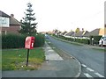
Letter box, Malham Road, Field Lane Estate, Rastrick
This is at the junction with Arnold Royd The letter box is number HD6 419 and is of the lamp box type mounted on a pole. The cypher is EiiR, fairly old as it has 'POST OFFICE' rather than 'ROYAL MAIL'.
Image: © Humphrey Bolton
Taken: 6 Jan 2009
0.07 miles
5
View from Arncliffe Crescent, Field Lane Estate, Rastrick
Arncliffe Crescent is staple-shaped, and from the start of the curve you can look forwards across a play area towards the Children's Centre.
Image: © Humphrey Bolton
Taken: 6 Jan 2009
0.07 miles
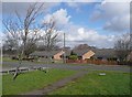
6
Mobile library at Wensley Grove, Field Lane Estate, Rastrick
Parked in a quiet cul-de-sac.
Image: © Humphrey Bolton
Taken: 6 Jan 2009
0.07 miles
7
Arncliffe Drive, Rastrick
Seen from the grassed area stretching down from Malham Road.
Image: © Humphrey Bolton
Taken: 6 Mar 2009
0.07 miles
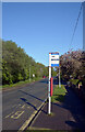
9
Nunnery Lane seen from Lower Edge Road, Rastrick
Image: © habiloid
Taken: 7 May 2022
0.09 miles
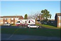
10
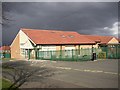
Children's Centre, Burnsall Road, Rastrick
This recent building is next to the primary school, and was opened by Gordon Brown on 7 Jan 05. It provides a wide range of education, health family support and employment services for local people, including nursery and foundation stage education.
Image: © Humphrey Bolton
Taken: 8 Apr 2006
0.09 miles