IMAGES TAKEN NEAR TO
Malham Avenue, BRIGHOUSE, HD6 3JU
Introduction
This page details the photographs taken nearby to Malham Avenue, HD6 3JU by members of the Geograph project.
The Geograph project started in 2005 with the aim of publishing, organising and preserving representative images for every square kilometre of Great Britain, Ireland and the Isle of Man.

There are currently over 7.5m images from over14,400 individuals and you can help contribute to the project by visiting https://www.geograph.org.uk
Image Map
Images are licensed for reuse under creativecommons.org/licenses/by-sa/2.0
Notes
- Clicking on the map will re-center to the selected point.
- The higher the marker number, the further away the image location is from the centre of the postcode.
Image Listing (123 Images Found)
Images are licensed for reuse under creativecommons.org/licenses/by-sa/2.0
Image
Details
Distance
1
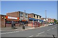
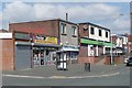
Shops, Highfield Road, Rastrick
These were built to serve a large council estate. Why put the shops into concrete boxes when the houses are in traditional designs with pitched roofs?
Image: © Humphrey Bolton
Taken: 1 May 2007
0.03 miles
2
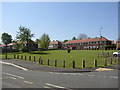
Open space off Highfield Road, Rastrick
I suppose grass is all that the council can afford nowadays, but at least it is neat and tidy.
Image: © Humphrey Bolton
Taken: 1 May 2007
0.03 miles
3
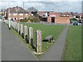
Short Cut, Field lane Estate, Rastrick
A path has been made across the grass from Malham Road to Malham Avenue and the shops on Highfield Road.
Image: © Humphrey Bolton
Taken: 6 Mar 2009
0.03 miles
4
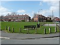
Grassed area and seat
The seat has appeared since I took the previous photograph. Presumably the posts are to prevent, or at least deter, travellers from camping on the area.
Image: © Humphrey Bolton
Taken: 20 Apr 2013
0.03 miles
5
Shops, Highfield Road
Since my previous photograph the Co-op food store has changed colour from blue to green, the convenience store has changed to the Premier franchise, and a new unit, Curry Chef, has been opened at the left end.
Image: © Humphrey Bolton
Taken: 20 Apr 2013
0.03 miles
6
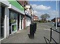
Anti-ram-raid posts
These are outside the entrance to the Co-op food store.
Image: © Humphrey Bolton
Taken: 20 Apr 2013
0.04 miles
7
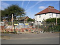
Building site, Hanson Road, Rastrick
Housing association dwellings are under construction next to a pair of ex-council houses with imaginative decoration at the corners.
Image: © Humphrey Bolton
Taken: 18 Sep 2007
0.04 miles
8
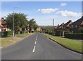
Holly Bank Road, Rastrick
This is the top end of the main spine road for the eastern part of the Field Lane estate.
Image: © Humphrey Bolton
Taken: 18 Sep 2007
0.04 miles
9
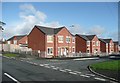
New houses, Hanson Road, Rastrick
This is a housing association development and has replaced a council care home.
Image: © Humphrey Bolton
Taken: 2 Nov 2009
0.04 miles
10
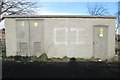
Electricity Substation No B458 - Malham Road
Image: © Betty Longbottom
Taken: 24 Dec 2013
0.05 miles