IMAGES TAKEN NEAR TO
Castle Terrace, BRIGHOUSE, HD6 3HU
Introduction
This page details the photographs taken nearby to Castle Terrace, HD6 3HU by members of the Geograph project.
The Geograph project started in 2005 with the aim of publishing, organising and preserving representative images for every square kilometre of Great Britain, Ireland and the Isle of Man.

There are currently over 7.5m images from over14,400 individuals and you can help contribute to the project by visiting https://www.geograph.org.uk
Image Map
Images are licensed for reuse under creativecommons.org/licenses/by-sa/2.0
Notes
- Clicking on the map will re-center to the selected point.
- The higher the marker number, the further away the image location is from the centre of the postcode.
Image Listing (182 Images Found)
Images are licensed for reuse under creativecommons.org/licenses/by-sa/2.0
Image
Details
Distance
1
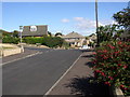
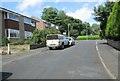
Close Lea Drive, Rastrick
Looking towards Ridge View Road, with the junction with Close Lea Way on the left.
Image: © Humphrey Bolton
Taken: 10 Sep 2007
0.03 miles
2
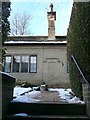
Thornton Cottage Homes, Rastrick
Well-hidden at the corner of Thornhill Road and Ridge View Road. The inscription records that they were 'erected by Mrs S. E. Atkinson A.D. 1921".
Image: © Humphrey Bolton
Taken: 9 Dec 2010
0.03 miles
5
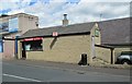
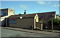
Castle Avenue Fisheries - Castle Avenue
Image: © Betty Longbottom
Taken: 30 Jul 2013
0.04 miles
6
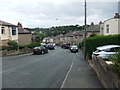
Close Lea Way - looking towards Field Top Road
Image: © Betty Longbottom
Taken: 30 Jul 2013
0.05 miles
7
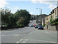
Thornhill Road- viewed from Barmston Street
Image: © Betty Longbottom
Taken: 30 Jul 2013
0.06 miles
8
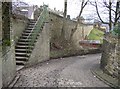
Brook Grain Hill, Rastrick (SE140219)
This is the old part of the lane, still with a surface of stone setts. The modern tarmac lane cuts across the semi-circular curve of this old lane. The steps lead up to Thornhill Road (A643) and the retaining wall was built when the road was widened many years ago.
Image: © Humphrey Bolton
Taken: 27 Feb 2006
0.06 miles
9
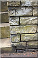
Benchmark on wall in front of #140 Thornhill Road
Ordnance Survey cut mark benchmark described on the Bench Mark Database at www.bench-marks.org.uk/bm41906
Image: © Roger Templeman
Taken: 18 Jul 2018
0.06 miles
10
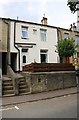
Steps to Nos. 140 and 144 Thornhill Road
There is an OS benchmark Image on the wall to the right of the right hand set of steps
Image: © Roger Templeman
Taken: 18 Jul 2018
0.06 miles