IMAGES TAKEN NEAR TO
Vicarage Gardens, BRIGHOUSE, HD6 3HD
Introduction
This page details the photographs taken nearby to Vicarage Gardens, HD6 3HD by members of the Geograph project.
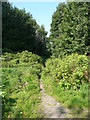
The Geograph project started in 2005 with the aim of publishing, organising and preserving representative images for every square kilometre of Great Britain, Ireland and the Isle of Man.

There are currently over 7.5m images from over14,400 individuals and you can help contribute to the project by visiting https://www.geograph.org.uk
Image Map
Images are licensed for reuse under creativecommons.org/licenses/by-sa/2.0
Notes
- Clicking on the map will re-center to the selected point.
- The higher the marker number, the further away the image location is from the centre of the postcode.
Image Listing (210 Images Found)
Images are licensed for reuse under creativecommons.org/licenses/by-sa/2.0
Image
Details
Distance
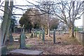
1
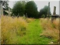
Looking along the churchyard of St Matthew's, Rastrick
This is the long narrow part that was added in 1862 on land that was presumably bought from Crow Trees.
Image: © Humphrey Bolton
Taken: 21 Jul 2023
0.02 miles
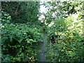
2
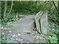
Abandoned pieces of stone next to Brighouse FP99, Rastrick
Stone was mined in this quarry, and these massive pieces must have been hauled up a shaft by a crane and then cut to rectangular shapes. Perhaps they were abandoned because pieces spalled off during the cutting. At present people do not walk this way, but have trodden a path on a different route.
Image: © Humphrey Bolton
Taken: 10 Sep 2015
0.03 miles
3
St Matthew's Churchyard, Vegetation Cleared
The Church community, with the help of the Probation Service have recently been putting a lot of effort into clearing litter, debris and vegetation from the previously overgrown Churchyard. the photo is taken at the south end facing north.
Image: © Richard Kay
Taken: 26 Feb 2008
0.03 miles
4
Diversion of Brighouse FP99 approaching Ogden Lane, Rastrick
The right-of-way is overgrown, and people have trodden a different route across an area that has been levelled in preparation for a development (housing?).
Image: © Humphrey Bolton
Taken: 10 Sep 2015
0.04 miles
5
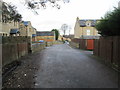
Vicarage Gardens - looking towards Ogden Lane
Image: © Betty Longbottom
Taken: 24 Dec 2013
0.04 miles
6
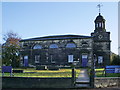
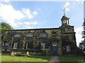
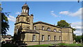
The Anglican and Methodist Church of St Matthew, Rastrick
Handsome ashlar-faced church of 1796-8. West tower with circular cupola.
Image: © Alexander P Kapp
Taken: 27 Oct 2008
0.04 miles
7
A branch of Brighouse FP99, Rastrick
The main path is a broad track to Toothill Bank. This branch goes to Ogden Lane.
Image: © Humphrey Bolton
Taken: 10 Sep 2015
0.04 miles
8
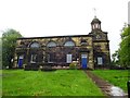
The Anglican and Methodist Church of St Matthew, Rastrick
Image: © Bill Henderson
Taken: 8 May 2014
0.05 miles