IMAGES TAKEN NEAR TO
Scholey Road, BRIGHOUSE, HD6 3EW
Introduction
This page details the photographs taken nearby to Scholey Road, HD6 3EW by members of the Geograph project.
The Geograph project started in 2005 with the aim of publishing, organising and preserving representative images for every square kilometre of Great Britain, Ireland and the Isle of Man.

There are currently over 7.5m images from over14,400 individuals and you can help contribute to the project by visiting https://www.geograph.org.uk
Image Map
Images are licensed for reuse under creativecommons.org/licenses/by-sa/2.0
Notes
- Clicking on the map will re-center to the selected point.
- The higher the marker number, the further away the image location is from the centre of the postcode.
Image Listing (145 Images Found)
Images are licensed for reuse under creativecommons.org/licenses/by-sa/2.0
Image
Details
Distance
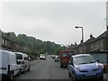
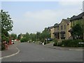
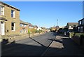
2
Scholey Road - looking towards Rastrick Common
Image: © Betty Longbottom
Taken: 30 Jul 2013
0.02 miles
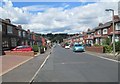
6
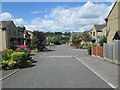
School Green - looking towards Rastrick Common
Image: © Betty Longbottom
Taken: 30 Jul 2013
0.06 miles
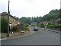
7
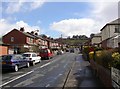
Scholey Road, Rastrick
This estate was built some time between 1934 and 1948 on fields named Scholey, Middle Scholey and Upper Scholey.
Image: © Humphrey Bolton
Taken: 8 Apr 2006
0.06 miles
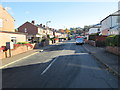
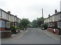
10
Rastrick Common - viewed from Scholey Road
Image: © Betty Longbottom
Taken: 19 Nov 2013
0.09 miles