IMAGES TAKEN NEAR TO
Rastrick Common, BRIGHOUSE, HD6 3EL
Introduction
This page details the photographs taken nearby to Rastrick Common, HD6 3EL by members of the Geograph project.
The Geograph project started in 2005 with the aim of publishing, organising and preserving representative images for every square kilometre of Great Britain, Ireland and the Isle of Man.

There are currently over 7.5m images from over14,400 individuals and you can help contribute to the project by visiting https://www.geograph.org.uk
Image Map
Images are licensed for reuse under creativecommons.org/licenses/by-sa/2.0
Notes
- Clicking on the map will re-center to the selected point.
- The higher the marker number, the further away the image location is from the centre of the postcode.
Image Listing (206 Images Found)
Images are licensed for reuse under creativecommons.org/licenses/by-sa/2.0
Image
Details
Distance
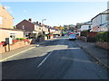
1

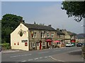
Rastrick Common - viewed from Scholey Road
Image: © Betty Longbottom
Taken: 19 Nov 2013
0.01 miles
3
Rastrick Common - viewed from Scholey Road
Image: © Betty Longbottom
Taken: 19 Nov 2013
0.04 miles
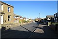
4
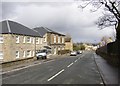
Scholey Road, Rastrick
This estate was built some time between 1934 and 1948 on fields named Scholey, Middle Scholey and Upper Scholey.
Image: © Humphrey Bolton
Taken: 8 Apr 2006
0.04 miles
6

Rosemary Lane, Rastrick
A narrow cobbled lane that used to lead to a dye works, now a housing estate. The OS New Popular 1" map shows the A643 along here - I don't believe it!
Image: © Humphrey Bolton
Taken: 22 Sep 2005
0.06 miles
7
Bramston Gardens, Rastrick
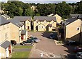
This is a birdseye view of this modern housing estate from Thornhill Road. The site was formerly a dyeworks.
Image: © Humphrey Bolton
Taken: 6 Aug 2007
0.06 miles
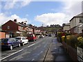
9
Ivy House, Rastrick Common, Rastrick
Ivy House was originally the home of the owner of the mill on the adjacent Rosemary Lane, and it was subsequently extended and used as an "old folks home". It has recently been extensively refurbished by the Cygnet group as one of their treatment facilities.
Rastrick Common is the road name - the common has long since been enclosed.
Image: © Humphrey Bolton
Taken: 8 Apr 2006
0.07 miles
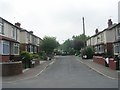
10
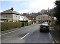
Sunnydale Avenue, Rastrick
This estate was built some time between 1934 and 1948 on a field named Croft.
Image: © Humphrey Bolton
Taken: 8 Apr 2006
0.07 miles