IMAGES TAKEN NEAR TO
Brooke Street, BRIGHOUSE, HD6 3DT
Introduction
This page details the photographs taken nearby to Brooke Street, HD6 3DT by members of the Geograph project.
The Geograph project started in 2005 with the aim of publishing, organising and preserving representative images for every square kilometre of Great Britain, Ireland and the Isle of Man.

There are currently over 7.5m images from over14,400 individuals and you can help contribute to the project by visiting https://www.geograph.org.uk
Image Map
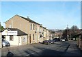
Images are licensed for reuse under creativecommons.org/licenses/by-sa/2.0
Notes
- Clicking on the map will re-center to the selected point.
- The higher the marker number, the further away the image location is from the centre of the postcode.
Image Listing (282 Images Found)
Images are licensed for reuse under creativecommons.org/licenses/by-sa/2.0
Image
Details
Distance
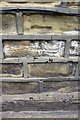
2
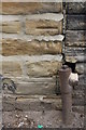
Benchmark on Pennine Pneumatic Services works, Rastrick Common
Image: © Luke Shaw
Taken: 18 Jul 2018
0.02 miles
3
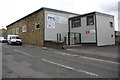
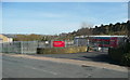
Pennine Pneumatic Services factory, Rastrick Common
There is an OS benchmark Image on the near corner, road face, of the main part of the building
Image: © Luke Shaw
Taken: 18 Jul 2018
0.02 miles
4
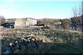
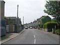
Vacant plot, Rastrick Common
At the junction with Gooder Lane. There were several little cottages here, and the area to the right was the Brighouse Brick and Tile Works.
Image: © Humphrey Bolton
Taken: 17 Dec 2010
0.02 miles
5
Caroles Canine Cuts, Rastrick Common
A hairdresser for dogs in a little cottage near the top of Bridge End. The ghost in the road followed me all morning.
Image: © Humphrey Bolton
Taken: 17 Dec 2010
0.02 miles
6
Customer entrance to Alco Valves, Rastrick Common
This is a redevelopment of a derelict site (see Image), which had been a clay pit for the Brighouse Brick and Tile Works, with a row of houses along the road.
Image: © Humphrey Bolton
Taken: 26 Mar 2017
0.03 miles
7
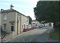
Oldham Street, off Bridge End, Rastrick
This street went through to Gooder Lane, but the far end was renamed as Green End when the area was redeveloped.
Image: © Humphrey Bolton
Taken: 15 Aug 2008
0.04 miles
9
Benchmark on #54 Bridge End
Ordnance Survey cut mark benchmark described on the Bench Mark Database at www.bench-marks.org.uk/bm41903
Image: © Roger Templeman
Taken: 18 Jul 2018
0.04 miles
10
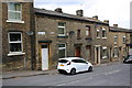
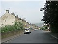
Houses on Bridge End
There is an OS benchmark Image on the wall of the house between its white door and the white car
Image: © Roger Templeman
Taken: 18 Jul 2018
0.05 miles