IMAGES TAKEN NEAR TO
Thornhill Road, BRIGHOUSE, HD6 3AX
Introduction
This page details the photographs taken nearby to Thornhill Road, HD6 3AX by members of the Geograph project.
The Geograph project started in 2005 with the aim of publishing, organising and preserving representative images for every square kilometre of Great Britain, Ireland and the Isle of Man.

There are currently over 7.5m images from over14,400 individuals and you can help contribute to the project by visiting https://www.geograph.org.uk
Image Map
Images are licensed for reuse under creativecommons.org/licenses/by-sa/2.0
Notes
- Clicking on the map will re-center to the selected point.
- The higher the marker number, the further away the image location is from the centre of the postcode.
Image Listing (349 Images Found)
Images are licensed for reuse under creativecommons.org/licenses/by-sa/2.0
Image
Details
Distance
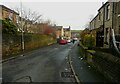
2
Benchmark on #16 Thomas Street
Ordnance Survey cut mark benchmark described on the Bench Mark Database at www.bench-marks.org.uk/bm41904
Image: © Roger Templeman
Taken: 18 Jul 2018
0.02 miles
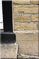
3
Ordnance Survey Cut Mark
This mark can be found on the wall of 16 Thomas Street.
For more details see : http://www.bench-marks.org.uk/bm41904
Image: © Peter Wood
Taken: 13 Mar 2012
0.02 miles
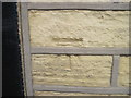
4
Houses of Thomas Street at Bryan Street junction
There is an OS benchmark Image on the house wall right of the middle white door
Image: © Roger Templeman
Taken: 18 Jul 2018
0.02 miles
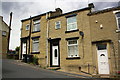
5
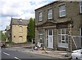
Former Co-op shop, Thornhill Road, Rastrick
Watch this space!
Image: © Humphrey Bolton
Taken: 22 Jul 2007
0.03 miles
7
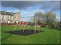
Play area off George Street, Rastrick
A block of property has been demolished here and the land grassed over for recreation.
Image: © Humphrey Bolton
Taken: 2 Nov 2009
0.03 miles
8
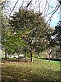
Landscaped area off George Street, Rastrick
This occupies a plot where there were terrace houses, along Bryan Street, and their gardens. The railway viaduct can just be seen in the distance.
Image: © Humphrey Bolton
Taken: 2 Nov 2009
0.03 miles
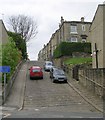
9
Lillands Lane, Rastrick
This is the eastern end of the road; it meets Thornhill Road at the top of the hill. There were many houses on the right, including one row that tapered so that each house was smaller than the last.
Image: © Humphrey Bolton
Taken: 23 Feb 2009
0.03 miles
10
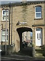
Archway to George Terrace, George Street, Rastrick
This is the way through the terrace houses along George Street to the rear houses of back-to-backs fronting onto Thornhill Road. The small sign indicates that this back street is not an adopted highway.
Image: © Humphrey Bolton
Taken: 2 Nov 2009
0.03 miles