IMAGES TAKEN NEAR TO
Longroyde Road, BRIGHOUSE, HD6 3AS
Introduction
This page details the photographs taken nearby to Longroyde Road, HD6 3AS by members of the Geograph project.
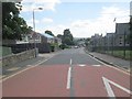
The Geograph project started in 2005 with the aim of publishing, organising and preserving representative images for every square kilometre of Great Britain, Ireland and the Isle of Man.

There are currently over 7.5m images from over14,400 individuals and you can help contribute to the project by visiting https://www.geograph.org.uk
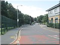
Image Map
Images are licensed for reuse under creativecommons.org/licenses/by-sa/2.0
Notes
- Clicking on the map will re-center to the selected point.
- The higher the marker number, the further away the image location is from the centre of the postcode.
Image Listing (177 Images Found)
Images are licensed for reuse under creativecommons.org/licenses/by-sa/2.0
Image
Details
Distance
1
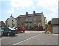
Houses, Closes Road, Rastrick
Closes Road was a narrow road from Thornhill Road to an area of land called Brighouse Closes. The footpath to the right of the houses is the last remaining part of this road. The houses were built at right-angles to the road. The part down to Thornhill Road has been built over and replaced by Thornes Park and Calder View. Notice that the house on the right was formerly two houses; one of the windows was a doorway.
Image: © Humphrey Bolton
Taken: 22 Jul 2007
0.02 miles
2
Calder View, Rastrick
Looking towards the junction with Thornes Park.
Image: © Humphrey Bolton
Taken: 22 Jul 2007
0.02 miles
3
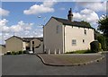
Closes Place, Rastrick
An old house retained within a modern housing estate. It is on a remnant of Closes Road, represented by the light grey footway with the bollards.
Image: © Humphrey Bolton
Taken: 22 Jul 2007
0.02 miles
4
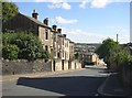
Longroyde Road, off Thornhill Road, Rastrick
The terrace houses are part of the locality called Little Woodhouse on old maps, and are shown on the 1:500 OS town plan of 1890.
Image: © Humphrey Bolton
Taken: 10 Sep 2007
0.02 miles
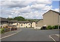
6
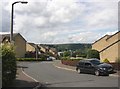
Calder View, Rastrick
This is the newest part of the estate, looking down, as the name suggests, towards the Calder valley.
Image: © Humphrey Bolton
Taken: 22 Jul 2007
0.04 miles
7
Oaklands - viewed from Longroyde Road
Image: © Betty Longbottom
Taken: 30 Jul 2013
0.05 miles
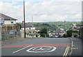
9
Field Top Road - viewed from Longroyde Road
Image: © Betty Longbottom
Taken: 30 Jul 2013
0.06 miles
10
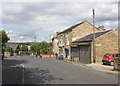
Newsagent's shop, Thornhill Road, Rastrick
The sign on the side of the single-storey building is for Thornhill Place, which is a yard faced by four small houses and leading to York Street.
Image: © Humphrey Bolton
Taken: 22 Jul 2007
0.07 miles