IMAGES TAKEN NEAR TO
Ridge View Road, BRIGHOUSE, HD6 3AN
Introduction
This page details the photographs taken nearby to Ridge View Road, HD6 3AN by members of the Geograph project.
The Geograph project started in 2005 with the aim of publishing, organising and preserving representative images for every square kilometre of Great Britain, Ireland and the Isle of Man.

There are currently over 7.5m images from over14,400 individuals and you can help contribute to the project by visiting https://www.geograph.org.uk
Image Map
Images are licensed for reuse under creativecommons.org/licenses/by-sa/2.0
Notes
- Clicking on the map will re-center to the selected point.
- The higher the marker number, the further away the image location is from the centre of the postcode.
Image Listing (175 Images Found)
Images are licensed for reuse under creativecommons.org/licenses/by-sa/2.0
Image
Details
Distance
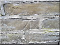
1
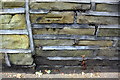
Benchmark on wall in front of #100 Thornhill Road at #102 junction
Ordnance Survey cut mark benchmark described on the Bench Mark Database at www.bench-marks.org.uk/bm41905
Image: © Roger Templeman
Taken: 18 Jul 2018
0.02 miles
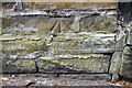
3
Ordnance Survey Cut Mark
This mark can be found on the roadside garden wall of 100 Thornhill Road.
For more details see : http://www.bench-marks.org.uk/bm41905
Image: © Peter Wood
Taken: 13 Mar 2012
0.03 miles
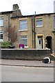
4
Back Thornhill Road, Rastrick
This is the back street off Ridge View Road, extending 200m to Longroyde Road.
Image: © Humphrey Bolton
Taken: 9 Dec 2010
0.03 miles
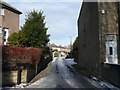
5
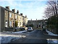
Ridge View Road, Rastrick
A short street from Thornhill Road, in the background, to the back street that crosses in the foreground. It was made in the early 20C (after 1905). Taken from Close Lea, a housing estate built in the late 20C. The gateway in the wall on the right leads to the rear of the Thornton Cottage Homes.
Image: © Humphrey Bolton
Taken: 9 Dec 2010
0.03 miles
6
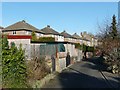
Back Close Lea, Rastrick
This back lane gives rear access to houses in both Thornhill Road and Close Lea.
Image: © Humphrey Bolton
Taken: 17 Dec 2010
0.03 miles
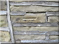
7
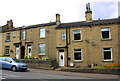
Houses on Bramston Street
There is an OS benchmark Image on the road face of the wall angle in the middle of the image
Image: © Roger Templeman
Taken: 18 Jul 2018
0.03 miles
8
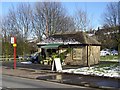
Florist's shop, Bramston Street, Rastrick
Public conveniences are an endangered species; this one has been converted into a shop. Note the blocked-up doorway on the right.
Image: © Humphrey Bolton
Taken: 4 Mar 2006
0.04 miles
9
Ordnance Survey Cut Mark
This mark can be found on the wall of 134 Bramston Street.
For more details see : http://www.bench-marks.org.uk/bm41907
Image: © Peter Wood
Taken: 13 Mar 2012
0.04 miles
10
Benchmark on wall in front of #134 Bramston Street
Ordnance Survey cut mark benchmark described on the Bench Mark Database at www.bench-marks.org.uk/bm41907
Image: © Roger Templeman
Taken: 18 Jul 2018
0.04 miles