IMAGES TAKEN NEAR TO
York Street, BRIGHOUSE, HD6 3AL
Introduction
This page details the photographs taken nearby to York Street, HD6 3AL by members of the Geograph project.
The Geograph project started in 2005 with the aim of publishing, organising and preserving representative images for every square kilometre of Great Britain, Ireland and the Isle of Man.

There are currently over 7.5m images from over14,400 individuals and you can help contribute to the project by visiting https://www.geograph.org.uk
Image Map
Images are licensed for reuse under creativecommons.org/licenses/by-sa/2.0
Notes
- Clicking on the map will re-center to the selected point.
- The higher the marker number, the further away the image location is from the centre of the postcode.
Image Listing (234 Images Found)
Images are licensed for reuse under creativecommons.org/licenses/by-sa/2.0
Image
Details
Distance
1
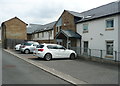
Entrance to apartment block, Back Close Lea, Rastrick
These apartments were built on the site of Thorncliff Villa, an old house shown and named on the 1854 1:500 map. Here is a photograph taken during the early stages of construction: Image
Image: © Humphrey Bolton
Taken: 24 Jul 2018
0.02 miles
2
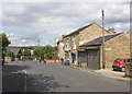
Newsagent's shop, Thornhill Road, Rastrick
The sign on the side of the single-storey building is for Thornhill Place, which is a yard faced by four small houses and leading to York Street.
Image: © Humphrey Bolton
Taken: 22 Jul 2007
0.03 miles
3
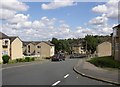
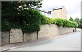
Thornes Park, Rastrick
Looking down towards Thornhill Road.
Image: © Humphrey Bolton
Taken: 22 Jul 2007
0.03 miles
4
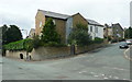
Apartment block on the site of Thorncliff Villa, Rastrick
Unfortunately I had not previously taken a photograph of the old house, which was shown on the 1854 1:500 map and was quite large. The 1958-9 1:1250 map shows half of it as being a surgery; the other half was presumably the doctor's house. A later edition shows it divided into two houses.
Image: © Humphrey Bolton
Taken: 24 Jul 2018
0.03 miles
5
Thornhill Road approaching Longroyde Road junction
Image: © Roger Templeman
Taken: 18 Jul 2018
0.03 miles
6
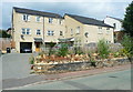
New houses, Thornhill Road, Rastrick
Most of the houses in the street are 19C terrace houses, but here there was only two old houses and the site has been redeveloped.
Image: © Humphrey Bolton
Taken: 24 Jul 2018
0.03 miles
7
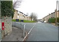
Letter box, Thornhill Road, Rastrick
Letter box HD6 270, an EiiR wall box, molested by graffiti vandals. The road to the left is Longroyde Road, and ahead 19C terrace houses on the right and council flats on the left on what were allotments.
Image: © Humphrey Bolton
Taken: 5 Jan 2009
0.04 miles
8
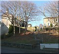
Steps from Denham Street to Bramston Street, Rastrick
Not an old footpath, but it seems that this part of the hillside has never been built on and probably so many people walked down the slope that the council were eventually persuaded to make some steps.
Image: © Humphrey Bolton
Taken: 17 Dec 2010
0.04 miles
9
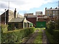
The Brandy Snap Works, Bramston Street, Rastrick
Advertised by a small sign on the wall, but you have to peek over a tall wooden gate to see it.
Image: © Humphrey Bolton
Taken: 10 Apr 2006
0.05 miles
10

Bramston Street (A643), Rastrick
This road was made in the late 19C. It was as a wider, better graded route than Thornhill Road, which was originally a private road belonging to the Thornhill estate. In the mid-20C Bramston Street was 'promoted' to A road status, replacing Rastrick Common / Bridge End. From old maps it seems that the modern houses on the left were built on a vacant hillside, and did not replace old slum houses.
Image: © Humphrey Bolton
Taken: 30 Jul 2009
0.05 miles