IMAGES TAKEN NEAR TO
Thornhill Road, BRIGHOUSE, HD6 3AH
Introduction
This page details the photographs taken nearby to Thornhill Road, HD6 3AH by members of the Geograph project.
The Geograph project started in 2005 with the aim of publishing, organising and preserving representative images for every square kilometre of Great Britain, Ireland and the Isle of Man.

There are currently over 7.5m images from over14,400 individuals and you can help contribute to the project by visiting https://www.geograph.org.uk
Image Map
Images are licensed for reuse under creativecommons.org/licenses/by-sa/2.0
Notes
- Clicking on the map will re-center to the selected point.
- The higher the marker number, the further away the image location is from the centre of the postcode.
Image Listing (185 Images Found)
Images are licensed for reuse under creativecommons.org/licenses/by-sa/2.0
Image
Details
Distance
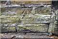
1
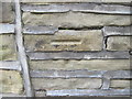
Ordnance Survey Cut Mark
This mark can be found on the roadside garden wall of 100 Thornhill Road.
For more details see : http://www.bench-marks.org.uk/bm41905
Image: © Peter Wood
Taken: 13 Mar 2012
0.01 miles
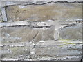
2
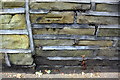
Benchmark on wall in front of #100 Thornhill Road at #102 junction
Ordnance Survey cut mark benchmark described on the Bench Mark Database at www.bench-marks.org.uk/bm41905
Image: © Roger Templeman
Taken: 18 Jul 2018
0.01 miles
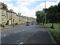
3
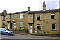
Houses on Bramston Street
There is an OS benchmark Image on the road face of the wall angle in the middle of the image
Image: © Roger Templeman
Taken: 18 Jul 2018
0.02 miles
5
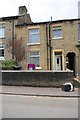
Benchmark on wall in front of #134 Bramston Street
Ordnance Survey cut mark benchmark described on the Bench Mark Database at www.bench-marks.org.uk/bm41907
Image: © Roger Templeman
Taken: 18 Jul 2018
0.02 miles
6
Ordnance Survey Cut Mark
This mark can be found on the wall of 134 Bramston Street.
For more details see : http://www.bench-marks.org.uk/bm41907
Image: © Peter Wood
Taken: 13 Mar 2012
0.02 miles
7
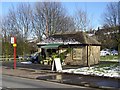
Florist's shop, Bramston Street, Rastrick
Public conveniences are an endangered species; this one has been converted into a shop. Note the blocked-up doorway on the right.
Image: © Humphrey Bolton
Taken: 4 Mar 2006
0.03 miles
8
Bramston Street - viewed from Bramston Gardens
Image: © Betty Longbottom
Taken: 30 Jul 2013
0.03 miles
9
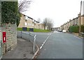
Letter box, Thornhill Road, Rastrick
Letter box HD6 270, an EiiR wall box, molested by graffiti vandals. The road to the left is Longroyde Road, and ahead 19C terrace houses on the right and council flats on the left on what were allotments.
Image: © Humphrey Bolton
Taken: 5 Jan 2009
0.03 miles
10
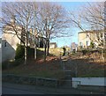
Steps from Denham Street to Bramston Street, Rastrick
Not an old footpath, but it seems that this part of the hillside has never been built on and probably so many people walked down the slope that the council were eventually persuaded to make some steps.
Image: © Humphrey Bolton
Taken: 17 Dec 2010
0.03 miles