IMAGES TAKEN NEAR TO
Mount Lane, BRIGHOUSE, HD6 3AB
Introduction
This page details the photographs taken nearby to Mount Lane, HD6 3AB by members of the Geograph project.
The Geograph project started in 2005 with the aim of publishing, organising and preserving representative images for every square kilometre of Great Britain, Ireland and the Isle of Man.

There are currently over 7.5m images from over14,400 individuals and you can help contribute to the project by visiting https://www.geograph.org.uk
Image Map
Images are licensed for reuse under creativecommons.org/licenses/by-sa/2.0
Notes
- Clicking on the map will re-center to the selected point.
- The higher the marker number, the further away the image location is from the centre of the postcode.
Image Listing (256 Images Found)
Images are licensed for reuse under creativecommons.org/licenses/by-sa/2.0
Image
Details
Distance
1
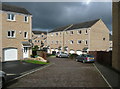
Sage Grove, Rastrick
Part of the Spout Hill development. The street has not been adopted (according to the council's map with transport network overlay), perhaps because it is surfaced with block paving and has no footways. Just before the gable-end Brighouse FP103 slopes down to the right.
Image: © Humphrey Bolton
Taken: 26 Sep 2014
0.03 miles
2
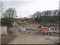
Spout Hill, Rastrick (SE133209)
This led to Spout Mills, but these were burnt down several years ago and the site was derelict until redevelopment for houses started recently. At the bottom of the hill, Mount Lane swings round to the right and leads to the terrace of houses in the distance called Mount Pleasant.
Image: © Humphrey Bolton
Taken: 11 Mar 2006
0.05 miles
3
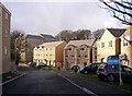
Spout Hill, Rastrick
A previous photograph from approximately this position showed this development in the early stages of construction. Unfortunately I did not see it when Spout Mills was still here.
Image: © Humphrey Bolton
Taken: 5 Feb 2008
0.05 miles
4
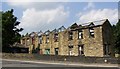
Derelict mill offices and workshop, Spout Hill, off New Hey Road, Rastrick
This was demolished to make way for a block of flats in the Spout Hill development. A brass plaque by the doorway on the right reads 'THOMAS HELM AND SONS'. The mill down the hill had been demolished by 2004 and has now been redeveloped with tall town-houses.
I have been informed that: "the rear of the building with the large windows was the Burling and Mending Shed, staffed mainly by women who picked out and/or sewed in the loose threads in large bolts of the finished cloth that hung from the roof of the building. It was hard, painstaking work that required good light, good eyesight and manual dexterity.".
Image: © Humphrey Bolton
Taken: 17 Aug 2005
0.05 miles
5
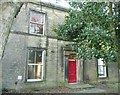
Croft House, New Hey Road, Rastrick
I should think that this house was probably built for a manager at Spout Mills nearby. It has been empty for a while, but it looks as if it is now being refurbished. It has a fire escape at the side, so has perhaps been used for offices or flats. The tall privet hedge alongside the road has been reduced, revealing this view of the front.
Image: © Humphrey Bolton
Taken: 6 Jan 2009
0.05 miles
6
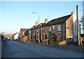
Terrace houses, New Hey Road, Rastrick
These are back-to back, the yard the back is New Road Square. New Road Sunday School is the next building.
Image: © Humphrey Bolton
Taken: 6 Jan 2009
0.05 miles
7

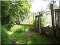
Brighouse FP103 climbing up to Sage Grove
The developer of the former mill site constructed steps here at first, but there were protests, presumably because that made the path too urban in character.
Image: © Humphrey Bolton
Taken: 26 Sep 2014
0.05 miles
8
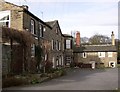
Delf Place, Rastrick (SE134210)
This is a few 19C houses grouped around a yard at the top of Delf Hill.
Image: © Humphrey Bolton
Taken: 27 Feb 2006
0.05 miles
9
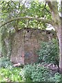
Corner of wall to former mill reservoir off Spout Hill, Rastrick
Spout Mills were demolished a few years ago, and the site is being redeveloped for housing. The reservoir has been filled in and new houses (unfortunately not captured by the camera) built above the wall.
Image: © Humphrey Bolton
Taken: 12 Jun 2006
0.05 miles
10
Smallholdings off Delf Hill, Rastrick
There is a row of smallholdings, mostly used for poultry, off the footpath between Delf Hill and Spout Hill.
Image: © Humphrey Bolton
Taken: 12 Jun 2006
0.05 miles