IMAGES TAKEN NEAR TO
Cromwell Bottom Drive, Elland Road, BRIGHOUSE, HD6 2SP
Introduction
This page details the photographs taken nearby to Cromwell Bottom Drive, Elland Road, HD6 2SP by members of the Geograph project.
The Geograph project started in 2005 with the aim of publishing, organising and preserving representative images for every square kilometre of Great Britain, Ireland and the Isle of Man.

There are currently over 7.5m images from over14,400 individuals and you can help contribute to the project by visiting https://www.geograph.org.uk
Image Map
Images are licensed for reuse under creativecommons.org/licenses/by-sa/2.0
Notes
- Clicking on the map will re-center to the selected point.
- The higher the marker number, the further away the image location is from the centre of the postcode.
Image Listing (87 Images Found)
Images are licensed for reuse under creativecommons.org/licenses/by-sa/2.0
Image
Details
Distance
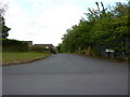
4
View of Cromwell Bottom, Southowram
The farm in the middle distance is called Fort Montague. Cromwell Bottom refers to the bottom end of the Cromwell valley, and also to a group of renovated houses on the far side of the main road, one of which can be seen towards the right side of the photo. In the distance the grain silos in Brighouse are surprisingly prominent. Their days are numbered - as soon as the redevelopment plans are sorted out they will surely be demolished.
Image: © Humphrey Bolton
Taken: 23 Sep 2006
0.09 miles
5
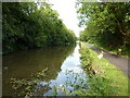
Calder & Hebble Navigation
East of Crowther Bridge
Image: © Alexander P Kapp
Taken: 15 Jul 2010
0.10 miles
6
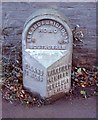
Old Milestone by the A6025, Elland Road, Cromwell Bottom
Brayshaw & Booth iron casting by the A6025, in parish of Brighouse (Calderdale District), Elland Road, Cromwell Bottom; 50m East of Ashgrove, back to brick wall.
Lost since 1970.
Inscription reads:-
: ELLAND / 1¾ MILES : : ELLAND & BRIGHOUSE / ROAD / SOUTHOWRAM : : WAKEFIELD / 14¾ MILES / DEWSBURY / 9 MILES / BRIGHOUSE / (1¾ MILES) :
Milestone Society National ID: YW_ELBH02
Image: © Milestone Society
Taken: Unknown
0.11 miles
7
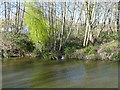
Stream flowing into the canal, Cromwell Bottom, Southowram
This is presumably the stream that comes down from the site of Far Binns. The canal is fed by many streams such as this, and there are overflow weirs to prevent the water level from getting too high. However it seems that in the storm of Boxing Day 2015 the flow into the canal was so great that the overflows could not cope. Possibly the river level might also have become so high that flow entered the canal.
Image: © Humphrey Bolton
Taken: 9 Mar 2017
0.13 miles
9
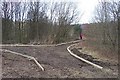
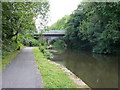
Footpath Improvement in Cromwell Bottom Nature Reserve
To the left the path leads to the River Calder Bailey Bridge; to the right the paths connect with the Towpaths alongside the Calder and Hebble Navigation canal. The path edging boards have been fixed during the last week and the ground prepared for a layer of stone.
Image: © Richard Kay
Taken: 6 Mar 2008
0.14 miles
10
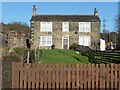
Cromwell House Farm
That was the name on the six-inch map of c.1910, but on the 1850 first edition it was captioned 'Stony Fields House'.
Image: © Humphrey Bolton
Taken: 2 Feb 2013
0.14 miles