IMAGES TAKEN NEAR TO
Grove Cottages, BRIGHOUSE, HD6 2RE
Introduction
This page details the photographs taken nearby to Grove Cottages, HD6 2RE by members of the Geograph project.
The Geograph project started in 2005 with the aim of publishing, organising and preserving representative images for every square kilometre of Great Britain, Ireland and the Isle of Man.

There are currently over 7.5m images from over14,400 individuals and you can help contribute to the project by visiting https://www.geograph.org.uk
Image Map
Images are licensed for reuse under creativecommons.org/licenses/by-sa/2.0
Notes
- Clicking on the map will re-center to the selected point.
- The higher the marker number, the further away the image location is from the centre of the postcode.
Image Listing (91 Images Found)
Images are licensed for reuse under creativecommons.org/licenses/by-sa/2.0
Image
Details
Distance
1
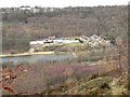
View of Grove, Southowram, Yorkshire
This is a view across the Calder valley from the footpath on the edge of the escarpment in Rastrick, and shows two terraces of 19C houses, Grove Cottages and Grove Terrace, originally back-to-backs. These are off the A6025 and were possibly built for quarry workers as there does not appear to have been a mill nearby. To the left of them is a hotel above the end of the water skiing lake, and at the top left of the picture a stone processing works associated with Cromwell Quarries.
Image: © Humphrey Bolton
Taken: 16 Feb 2006
0.04 miles
2

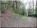
Track junction, Cromwell Wood Lane, Brookfoot, Southowram
To the right, Cromwell Wood Lane goes down to Elland Road opposite North Cut at Brookfoot. The track to the left is a public footpath leading via Cromwell Bottom Delf to Brookfoot Lane.
Image: © Humphrey Bolton
Taken: 7 Apr 2007
0.05 miles
4
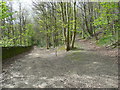
Junction of tracks in Freemans Wood, Southowram
The track to the left is Cromwell Wood Lane, part of Brighouse FP46, and the one to the left loops round via Delf Hill, and is part of FP45.
Image: © Humphrey Bolton
Taken: 13 Apr 2017
0.08 miles
6
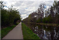
The Calder and Hebble Navigation west of Brookfoot Lock
Image: © habiloid
Taken: 15 Apr 2022
0.10 miles
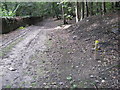
7
Junction of footpath with Cromwell Wood Lane, Southowram
The path to the left is part of Brighouse FP46 and goes to Brook Foot Lane.
Image: © Humphrey Bolton
Taken: 13 Apr 2017
0.10 miles
8
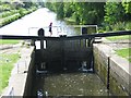
Walking Across The Lock Gates
Brookfoot Lock, Calder and Hebble Navigation.
Image: © Tim Marchant
Taken: 24 May 2008
0.10 miles
9
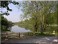
Brookfoot Lake, Southowram
This 1.4ha anglers' lake was created in the late 20C after gravel extraction, before which this area was fields.
Image: © Humphrey Bolton
Taken: 11 May 2006
0.10 miles
10
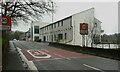
Casa hotel and restaurant, Elland Road, Southowram
Image: © Humphrey Bolton
Taken: 5 Apr 2023
0.10 miles