IMAGES TAKEN NEAR TO
Brighouse Wood Lane, BRIGHOUSE, HD6 2QU
Introduction
This page details the photographs taken nearby to Brighouse Wood Lane, HD6 2QU by members of the Geograph project.
The Geograph project started in 2005 with the aim of publishing, organising and preserving representative images for every square kilometre of Great Britain, Ireland and the Isle of Man.

There are currently over 7.5m images from over14,400 individuals and you can help contribute to the project by visiting https://www.geograph.org.uk
Image Map
Images are licensed for reuse under creativecommons.org/licenses/by-sa/2.0
Notes
- Clicking on the map will re-center to the selected point.
- The higher the marker number, the further away the image location is from the centre of the postcode.
Image Listing (201 Images Found)
Images are licensed for reuse under creativecommons.org/licenses/by-sa/2.0
Image
Details
Distance
1
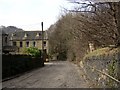
Brighouse Wood Lane, Brighouse
At SE138232. This steep cobbled road was the way from Brighouse to Halifax via Brookfoot and Southowram before the turnpike road was built in the valley.
Image: © Humphrey Bolton
Taken: 23 Mar 2006
0.01 miles
2
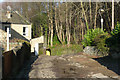
Brighouse Wood Row approaching Brighouse Wood Lane
The south-eastern end of Brighouse Wood is in the background.
Image: © Humphrey Bolton
Taken: 9 Dec 2019
0.02 miles
3
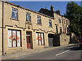
Brighouse District Industrial Society
Brighouse District Industrial Society Ltd Branch No 16, 1888.
Image: © Alan Bate
Taken: 8 Jan 2016
0.03 miles
4
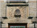
Carved panel over the door of the former co-op. Brookfoot, Brighouse
This proudly states that it was Branch 16, built in 1888. It closed in 1968.
Image: © Humphrey Bolton
Taken: 13 May 2021
0.03 miles
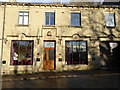
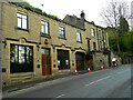
5
Old Co-op, Brookfoot, Brighouse
Like chapels, Co-op stores have often become redundant and found new uses. This one is identified by the beehive emblem over the door. It is on the A6025.
Image: © Humphrey Bolton
Taken: Unknown
0.03 miles
6
Former co-operative shop, Brookfoot
This was Branch 16, opened in 1888 and closed in 1968. The main change from Image], taken in 2005, is that the building is now the premises of a funeral director. For a close view of the carving over the door, with the beehive emblem, see Image
Image: © Humphrey Bolton
Taken: 13 May 2021
0.03 miles
7
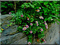
Erigeron glaucus, Elland Road, Brighouse
Common name Seaside fleabane. Native to the northern west coast of the USA, and imported to the UK as a garden plant. It likes full sun, but has colonised this wall despite it being in partial shade.
Image: © Humphrey Bolton
Taken: 14 Jul 2022
0.03 miles
8
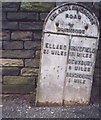
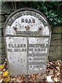
Old Milestone by the A6025, Elland Road, Brighouse
Milestone by the A6025, in parish of Brighouse (Calderdale District), Elland Road, West of Brighouse, near bend, opposite junction with Brighouse Wood Lane, opposite No. 100 old Co-op building.
Inscription reads:-
: ELLAND / 2¾ MILES : : ELLAND & BRIGHOUSE / ROAD / BRIGHOUSE : : WAKEFIELD / 13¾ MILES / DEWSBURY / 8 MILES / BRIGHOUSE / ¾ MILE :
Grade II listed.
List Entry Number: 1133835 https://historicengland.org.uk/listing/the-list/list-entry/1133835
Milestone Society National ID: YW_ELBH03
Image: © Milestone Society
Taken: Unknown
0.04 miles
9
Old milestone
This flat West Riding CC milestone has been straightened up but not repainted. It is on Elland Road near a bend and opposite Brighouse Wood Lane. It is one of a few of these flat castings made at the Brayshaw and Booth foundry in Liversedge when the site was too narrow for the protruding attachment. The founders name can be seen above ELLAND on the lefthand side. The plate should be fastened to its own dedicated stone but that is lost. It is Grade II listed 338828.
Image: © Robert Glover
Taken: 8 Nov 2020
0.04 miles
10
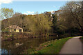
The Calder and Hebble Navigation, Brighouse
Red Beck joins the canal where the swan is in the distance.
Image: © habiloid
Taken: 15 Apr 2022
0.05 miles