IMAGES TAKEN NEAR TO
Woodbottom Lane, BRIGHOUSE, HD6 2QN
Introduction
This page details the photographs taken nearby to Woodbottom Lane, HD6 2QN by members of the Geograph project.
The Geograph project started in 2005 with the aim of publishing, organising and preserving representative images for every square kilometre of Great Britain, Ireland and the Isle of Man.

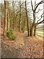
There are currently over 7.5m images from over14,400 individuals and you can help contribute to the project by visiting https://www.geograph.org.uk
Image Map
Images are licensed for reuse under creativecommons.org/licenses/by-sa/2.0
Notes
- Clicking on the map will re-center to the selected point.
- The higher the marker number, the further away the image location is from the centre of the postcode.
Image Listing (76 Images Found)
Images are licensed for reuse under creativecommons.org/licenses/by-sa/2.0
Image
Details
Distance
1
Lamp post on a footpath into Sutcliffe Wood, Hove Edge
Presumably disused, as it is not included on the street map layer on the Calderdale Council's online map.
Image: © Humphrey Bolton
Taken: 23 Mar 2020
0.01 miles
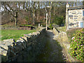
2
Footpath 49/3 to Sutcliffe Wood via Middlewood Farm, Hove Edge
The path turns left at the house and goes along the edge of the wood.
Image: © Humphrey Bolton
Taken: 26 Feb 2023
0.04 miles
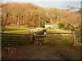
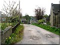
3
Wood Bottom Lane at a footpath junction, Hove Edge
Footpath 12/49/3 goes up into Sutcliffe Wood.
Image: © Humphrey Bolton
Taken: 7 May 2021
0.04 miles
4
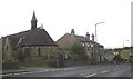
St Chad's Church, Hove Edge, Brighouse
Although now part of the built-up area of Brighouse, Hove Edge was at one time a hamlet in a rural setting. This church was completed in 1912 to serve the rapidly growing population.
Image: © Humphrey Bolton
Taken: 22 Aug 2005
0.06 miles
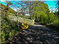
5
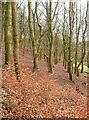
Footpath 49/3 along the bottom of Sutcliffe Wood, Hove Edge
Image: © Humphrey Bolton
Taken: 26 Feb 2023
0.08 miles
6
Sutcliffe Wood, Hove Edge
This view is looking along the hillside. There are beech saplings in the foreground, still with last year's leaves, dry and brown.
Image: © Humphrey Bolton
Taken: 26 Feb 2023
0.08 miles
7
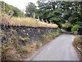
Fence posts, Wood Bottom Lane, Brighouse
Long disused, and leaning over alarmingly, these posts have a hole cut through them to take a beam of wood.
Image: © Humphrey Bolton
Taken: 22 Sep 2007
0.09 miles
8
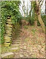
Steps on Footpath 49/1 in Sutcliffe Wood, Hove Edge
This is a long flight of steps up the hillside. The path goes to Halifax Road via Wood Top, and there is also a path along the top of the woods to Clog Sole Road.
Image: © Humphrey Bolton
Taken: 26 Feb 2023
0.10 miles
10
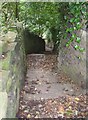
Steps on footpath, Sutcliffe Wood, Brighouse
This is the footpath from Halifax Road, at Hove Edge, down to Wood Bottom Lane. On the right a massive wall guards the wooded grounds of a house. I have been informed that these were known locally as the 'Cat's Steps'.
Image: © Humphrey Bolton
Taken: 22 Sep 2007
0.11 miles