IMAGES TAKEN NEAR TO
St. Chads Avenue, BRIGHOUSE, HD6 2PR
Introduction
This page details the photographs taken nearby to St. Chads Avenue, HD6 2PR by members of the Geograph project.
The Geograph project started in 2005 with the aim of publishing, organising and preserving representative images for every square kilometre of Great Britain, Ireland and the Isle of Man.

There are currently over 7.5m images from over14,400 individuals and you can help contribute to the project by visiting https://www.geograph.org.uk
Image Map
Images are licensed for reuse under creativecommons.org/licenses/by-sa/2.0
Notes
- Clicking on the map will re-center to the selected point.
- The higher the marker number, the further away the image location is from the centre of the postcode.
Image Listing (77 Images Found)
Images are licensed for reuse under creativecommons.org/licenses/by-sa/2.0
Image
Details
Distance
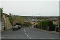
1
St Chad's C of E Primary School - Upper Green Lane, Hove Edge
Image: © Betty Longbottom
Taken: 3 May 2008
0.01 miles
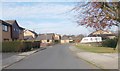
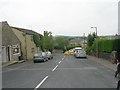
2
Green Lane - viewed from Spout House Lane
Image: © Betty Longbottom
Taken: 27 Jun 2009
0.04 miles
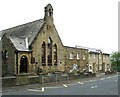
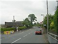
3
Trinity Academy St Chad, Hove Edge
Formerly St Chad CofE Primary School. The original building has evidently been extended twice.
Image: © Humphrey Bolton
Taken: 2 Dec 2021
0.05 miles
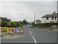
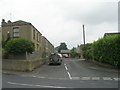
5
Spout House Lane - Upper Green Lane
Image: © Betty Longbottom
Taken: 27 Jun 2009
0.07 miles
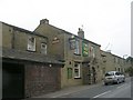
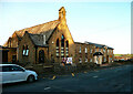
9
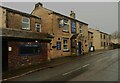
The Old Pond Public House, Spout House Lane, Hove Edge
This is an update on this Image], which was taken in 2009. Little change, but the Tetleys sign has gone.
Image: © Humphrey Bolton
Taken: 12 Jan 2023
0.09 miles