IMAGES TAKEN NEAR TO
Halifax Road, BRIGHOUSE, HD6 2EA
Introduction
This page details the photographs taken nearby to Halifax Road, HD6 2EA by members of the Geograph project.
The Geograph project started in 2005 with the aim of publishing, organising and preserving representative images for every square kilometre of Great Britain, Ireland and the Isle of Man.

There are currently over 7.5m images from over14,400 individuals and you can help contribute to the project by visiting https://www.geograph.org.uk
Image Map
Images are licensed for reuse under creativecommons.org/licenses/by-sa/2.0
Notes
- Clicking on the map will re-center to the selected point.
- The higher the marker number, the further away the image location is from the centre of the postcode.
Image Listing (315 Images Found)
Images are licensed for reuse under creativecommons.org/licenses/by-sa/2.0
Image
Details
Distance
1
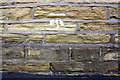
Benchmark on #1 Frances Street
Ordnance Survey cut mark benchmark described on the Bench Mark Database at www.bench-marks.org.uk/bm49236
Image: © Roger Templeman
Taken: 31 Jul 2018
0.01 miles
2
#1 Frances Street at Halifax Road junction
There is an OS benchmark Image near the corner, left hand face, of the nearest house
Image: © Roger Templeman
Taken: 31 Jul 2018
0.01 miles
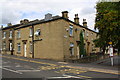
3
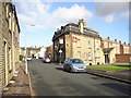
Houses on the site of Lane Head Methodist Chapel. Halifax Road, Brighouse
Brighouse Lane Head Primitive Methodist chapel was opened in 1889 and was demolished in 1985. The two modern houses were built on the site. The first Lane Head chapel was built in 1864 and incorporated an existing toll house. It seems that this became the Sunday school. The house on the right is probably the former toll house.
Image: © Humphrey Bolton
Taken: 24 Dec 2019
0.02 miles
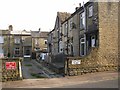
5
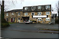
Lane Head Hotel, Brighouse Wood Lane, Brighouse
The house on the left has a door and window within a blocked arch like that of a barn or carriage house. The 1850 six-inch map shows a building where the hotel is now, but this had gone by the late 19C. Perhaps a former out-building was converted into a house when the old house was demolished.
Image: © Humphrey Bolton
Taken: 24 Dec 2019
0.03 miles
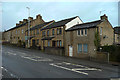
6
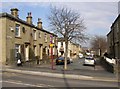
Frances Street, Brighouse
At SE141232. This is part of a 19C development off Halifax Road. The house on the left has a stone tablet carved with 'Frances Street 1865'. The junction with Halifax Road has been closed to traffic.
Image: © Humphrey Bolton
Taken: 23 Mar 2006
0.03 miles
7
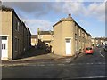
Back Charles Street, Waterloo Road, Brighouse
With the bottom end of Lightcliffe Road on the right. These houses were built to fill the plot; there were no front gardens, and if roads met at an angle the end house was tapered.
Image: © Humphrey Bolton
Taken: 21 Nov 2006
0.03 miles
8
Charles Street, Waterloo Road, Brighouse
The houses on the right are back-to-back with the houses on the west side of Back Charles Street.
Image: © Humphrey Bolton
Taken: 21 Nov 2006
0.03 miles
9
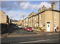
The Crown Hotel, Lightcliffe Road, Brighouse
With a mansard roof in the French style. The modern flats are on St Martin's View.
Image: © Humphrey Bolton
Taken: 21 Nov 2006
0.03 miles
10
Sculptor Place, Waterloo Road, Brighouse
The date on the lintel nearest the road is 1855.
Image: © Humphrey Bolton
Taken: 2 Apr 2007
0.03 miles