IMAGES TAKEN NEAR TO
Albion Street, BRIGHOUSE, HD6 2DZ
Introduction
This page details the photographs taken nearby to Albion Street, HD6 2DZ by members of the Geograph project.
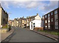
The Geograph project started in 2005 with the aim of publishing, organising and preserving representative images for every square kilometre of Great Britain, Ireland and the Isle of Man.

There are currently over 7.5m images from over14,400 individuals and you can help contribute to the project by visiting https://www.geograph.org.uk
Image Map
Images are licensed for reuse under creativecommons.org/licenses/by-sa/2.0
Notes
- Clicking on the map will re-center to the selected point.
- The higher the marker number, the further away the image location is from the centre of the postcode.
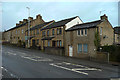
Image Listing (314 Images Found)
Images are licensed for reuse under creativecommons.org/licenses/by-sa/2.0
Image
Details
Distance
2
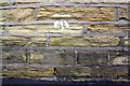
Benchmark on #1 Frances Street
Ordnance Survey cut mark benchmark described on the Bench Mark Database at www.bench-marks.org.uk/bm49236
Image: © Roger Templeman
Taken: 31 Jul 2018
0.02 miles
3
#1 Frances Street at Halifax Road junction
There is an OS benchmark Image near the corner, left hand face, of the nearest house
Image: © Roger Templeman
Taken: 31 Jul 2018
0.02 miles
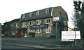
4
Bond Street, Lightcliffe Road, Brighouse
This street extends to Charles Street, but for some reason does not connect to it.
Image: © Humphrey Bolton
Taken: 21 Nov 2006
0.03 miles
5
Fish and chip shop, Lightcliffe Road, Brighouse
These traditional take-aways are holding their own against the various Chinese, Italian and Indian ones.
Image: © Humphrey Bolton
Taken: 21 Nov 2006
0.03 miles
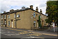
6
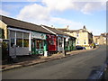
Row of shops, Lightcliffe Road, Brighouse
This row is just below Bond Street, and is shown on the 1:2500 map of 1907. The green one at the far end looks as if it might have its original shop-front.
Image: © Humphrey Bolton
Taken: 21 Nov 2006
0.03 miles
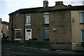

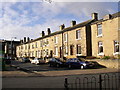
10
Houses on the site of Lane Head Methodist Chapel. Halifax Road, Brighouse
Brighouse Lane Head Primitive Methodist chapel was opened in 1889 and was demolished in 1985. The two modern houses were built on the site. The first Lane Head chapel was built in 1864 and incorporated an existing toll house. It seems that this became the Sunday school. The house on the right is probably the former toll house.
Image: © Humphrey Bolton
Taken: 24 Dec 2019
0.04 miles