IMAGES TAKEN NEAR TO
Sunnybank Grange, BRIGHOUSE, HD6 2DE
Introduction
This page details the photographs taken nearby to Sunnybank Grange, HD6 2DE by members of the Geograph project.
The Geograph project started in 2005 with the aim of publishing, organising and preserving representative images for every square kilometre of Great Britain, Ireland and the Isle of Man.

There are currently over 7.5m images from over14,400 individuals and you can help contribute to the project by visiting https://www.geograph.org.uk
Image Map
Images are licensed for reuse under creativecommons.org/licenses/by-sa/2.0
Notes
- Clicking on the map will re-center to the selected point.
- The higher the marker number, the further away the image location is from the centre of the postcode.
Image Listing (328 Images Found)
Images are licensed for reuse under creativecommons.org/licenses/by-sa/2.0
Image
Details
Distance
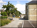
1
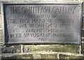
Plaque at the entrance to Rydings Park, Halifax Road, Brighouse
This is one of two similar plaques, one each side of the gateway. Unfortunately they have both been stolen.
Image: © Humphrey Bolton
Taken: 30 Apr 2007
0.02 miles
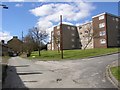
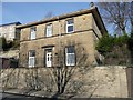
2
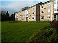
Sunnybank Terrace, Brighouse
These flats have a large lawn with shrubs and flower beds in front of them.
Image: © Humphrey Bolton
Taken: 24 Dec 2019
0.02 miles
3
Calder Valley View, Sunnybank Road, Brighouse
Image: © Humphrey Bolton
Taken: 22 Nov 2019
0.03 miles
6
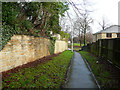
Sunnybank Terrace Footway, Brighouse
This leads from Sunnybank Terrace to Halifax Road. It was shown as a field access track on the 1850 six-inch map.
Image: © Humphrey Bolton
Taken: 24 Dec 2019
0.05 miles
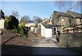
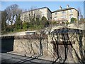
7
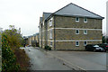
Sunny Bank Road, Brighouse
A narrow lane past a factory leads to these flats, and continues to the stone gateposts of a house.
Image: © Humphrey Bolton
Taken: 10 Apr 2006
0.06 miles
8
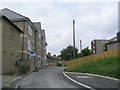
Back Halifax Road, Brighouse
Off Sunny Bank Road.
Image: © Humphrey Bolton
Taken: 17 Dec 2010
0.06 miles
9
Ganny Cottage, Elland Road, Brighouse
This is the original 19C name for the house, as shown on the 1850 six-inch map. The house is also indicated, but not named, on Myers's map of 1835.
Image: © Humphrey Bolton
Taken: 17 Dec 2010
0.06 miles
10
Flats and house, Sunny Bank Road, Brighouse
Seen from Elland Road.
Image: © Humphrey Bolton
Taken: 17 Dec 2010
0.06 miles