IMAGES TAKEN NEAR TO
Richard Place, BRIGHOUSE, HD6 2BZ
Introduction
This page details the photographs taken nearby to Richard Place, HD6 2BZ by members of the Geograph project.
The Geograph project started in 2005 with the aim of publishing, organising and preserving representative images for every square kilometre of Great Britain, Ireland and the Isle of Man.

There are currently over 7.5m images from over14,400 individuals and you can help contribute to the project by visiting https://www.geograph.org.uk
Image Map
Images are licensed for reuse under creativecommons.org/licenses/by-sa/2.0
Notes
- Clicking on the map will re-center to the selected point.
- The higher the marker number, the further away the image location is from the centre of the postcode.
Image Listing (268 Images Found)
Images are licensed for reuse under creativecommons.org/licenses/by-sa/2.0
Image
Details
Distance
1
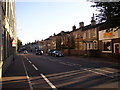
New Inn, Bradford Road, Brighouse
The inn and the house to the right are probably the buildings shown on the 1850 6" map, but the map does not show it as an inn.
Image: © Humphrey Bolton
Taken: 9 Oct 2006
0.03 miles
2
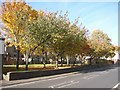
Long-span roof, Bradford Road, Brighouse
Probably created during slum clearance. The houses behind front onto Hey Street.
Image: © Humphrey Bolton
Taken: 30 Oct 2007
0.03 miles
4

Riding Floors Ltd, Richard Street, Brighouse
A commercial building in the suburbs. This was built on what appears on old maps to have been a slum clearance site. The business specialises in industrial and commercial flooring.
Image: © Humphrey Bolton
Taken: 13 Apr 2020
0.03 miles
7
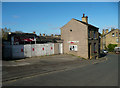
Car Wash, Thornhill Bridge Lane, Brighouse
Closed at present, like so much else.
Image: © Humphrey Bolton
Taken: 13 Apr 2020
0.03 miles
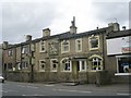
8
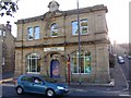
Former Co-op, Bradford Road, Brighouse
This is much grander than the shop that opened on the same day, 7th January 1889, at Brookfoot (SE1323). The broken pediment at the top has the beehive emblem of the Brighouse District Industrial Society, and above it a globe, perhaps anticipating world-wide expansion! It is an imposing building with massive pilasters at the corners and an ornate doorway. The date is 1888. It closed in the 1970s and now houses the Brighouse Evangelical Church.
Image: © Humphrey Bolton
Taken: 9 Oct 2006
0.04 miles
9
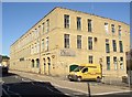
Mill building, Bradford Road, Brighouse
This must have seemed a modern building when it was built in 1909. It is good to see it cleaned and still in industrial use. On the 1907 map the site was occupied by a reservoir for Thornhill Briggs Mills.
Image: © Humphrey Bolton
Taken: 9 Oct 2006
0.04 miles
10
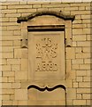
Datestone, Bradford Road, Brighouse
On a mill building at Thornhill Briggs. From a 1923 trade directory the initials stand for Wood Brothers and Sons Ltd.
Image: © Humphrey Bolton
Taken: 30 Apr 2007
0.04 miles