IMAGES TAKEN NEAR TO
Thornhill Bridge Lane, BRIGHOUSE, HD6 2BR
Introduction
This page details the photographs taken nearby to Thornhill Bridge Lane, HD6 2BR by members of the Geograph project.
The Geograph project started in 2005 with the aim of publishing, organising and preserving representative images for every square kilometre of Great Britain, Ireland and the Isle of Man.

There are currently over 7.5m images from over14,400 individuals and you can help contribute to the project by visiting https://www.geograph.org.uk
Image Map
Images are licensed for reuse under creativecommons.org/licenses/by-sa/2.0
Notes
- Clicking on the map will re-center to the selected point.
- The higher the marker number, the further away the image location is from the centre of the postcode.
Image Listing (325 Images Found)
Images are licensed for reuse under creativecommons.org/licenses/by-sa/2.0
Image
Details
Distance
1
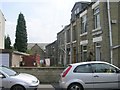
East Mount Place - East Mount Street
Image: © Betty Longbottom
Taken: 27 Jun 2009
0.00 miles
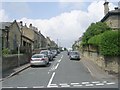
2
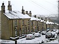
Anvil Street
Anvil Street from Thornhill Bridge Lane in the snow. About 3" fall of snow overnight and showers continuing through the morning.
Image: © Tim Marchant
Taken: 2 Feb 2009
0.02 miles
3
Housing block at Lee Street / Thornhill Bridge Lane junction
New housing on the site of Saint Andrew's Junior School
Image: © Roger Templeman
Taken: 31 Jul 2018
0.03 miles
4
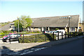
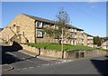
St Andrew's Court, Mary Street, Brighouse
This is a retirement housing development comprising 28 one-bedroom flats with communal facilities. It was built in 1987 on the site of St Andrew's Junior School.
Image: © Humphrey Bolton
Taken: 13 Apr 2020
0.03 miles
5
Marion Street - Thornhill Bridge Lane
Image: © Betty Longbottom
Taken: 27 Jun 2009
0.03 miles
6
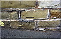
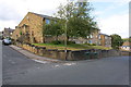
Benchmark on wall of Thornhill Bridge Lane
The wall originally the road face of an outbuilding of St Andrew's Junior School. Ordnance Survey cut mark benchmark described on the Bench Mark Database at https://www.bench-marks.org.uk/bm49282
Image: © Roger Templeman
Taken: 31 Jul 2018
0.03 miles
7
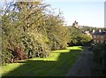
Garden between streets off Thornhill Bridge Lane, Brighouse
When I found this public garden between Firth Avenue and Vale Street I assumed that it had replaced a terrace of houses, but from old maps it seems that it has always been an open space.
Image: © Humphrey Bolton
Taken: 9 Oct 2006
0.03 miles
8
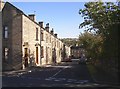
Firth Avenue, off Thornhill Bridge Lane, Brighouse
The 19C builders did not like to waste any space, and there are frequently odd-shaped houses at the end of terraces.
Image: © Humphrey Bolton
Taken: 9 Oct 2006
0.03 miles
9
Flats, Thornhill Bridge Lane, Brighouse
These are on the site of St Andrew's Church Schools, which had been built c.1884 and 1891 (Infants)..
Image: © Humphrey Bolton
Taken: 9 Oct 2006
0.03 miles
10
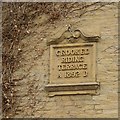
Datestone for Crooked Riding Terrace, Thornhills Bridge Lane, Brighouse
This is quite a large and elaborate datestone for a row of terrace houses, and has been placed on the blank gable-end. The houses face onto Anvil Street. Crooked Riding is the name of a house further down the street, although the second word is spelt Rhyding on one OS map and Ryding on another.
Image: © Humphrey Bolton
Taken: 26 Oct 2007
0.03 miles