IMAGES TAKEN NEAR TO
South Street, BRIGHOUSE, HD6 2BE
Introduction
This page details the photographs taken nearby to South Street, HD6 2BE by members of the Geograph project.
The Geograph project started in 2005 with the aim of publishing, organising and preserving representative images for every square kilometre of Great Britain, Ireland and the Isle of Man.

There are currently over 7.5m images from over14,400 individuals and you can help contribute to the project by visiting https://www.geograph.org.uk
Image Map
Images are licensed for reuse under creativecommons.org/licenses/by-sa/2.0
Notes
- Clicking on the map will re-center to the selected point.
- The higher the marker number, the further away the image location is from the centre of the postcode.
Image Listing (298 Images Found)
Images are licensed for reuse under creativecommons.org/licenses/by-sa/2.0
Image
Details
Distance
6
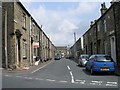
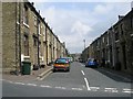
William Henry Street - Garden Road
Image: © Betty Longbottom
Taken: 27 Jun 2009
0.03 miles
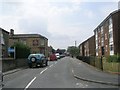
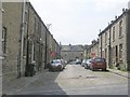
7
William Henry Street - Lightcliffe Road
Image: © Betty Longbottom
Taken: 27 Jun 2009
0.03 miles
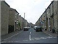
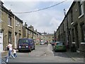
9
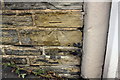
Benchmark on #20 Lightcliffe Road
Ordnance Survey cut mark benchmark described on the Bench Mark Database at www.bench-marks.org.uk/bm49251
Image: © Roger Templeman
Taken: 27 Jul 2018
0.04 miles
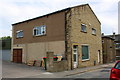
10
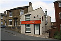
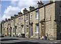
Nos. 20 and 18 (ALAMOS) Lightcliffe Road
There is an OS benchmark Image on the wall of #20 at its junction with #18 (left of a white downpipe)
Image: © Roger Templeman
Taken: 27 Jul 2018
0.04 miles