IMAGES TAKEN NEAR TO
Sunnybank Road, BRIGHOUSE, HD6 2BA
Introduction
This page details the photographs taken nearby to Sunnybank Road, HD6 2BA by members of the Geograph project.
The Geograph project started in 2005 with the aim of publishing, organising and preserving representative images for every square kilometre of Great Britain, Ireland and the Isle of Man.

There are currently over 7.5m images from over14,400 individuals and you can help contribute to the project by visiting https://www.geograph.org.uk
Image Map
Images are licensed for reuse under creativecommons.org/licenses/by-sa/2.0
Notes
- Clicking on the map will re-center to the selected point.
- The higher the marker number, the further away the image location is from the centre of the postcode.
Image Listing (462 Images Found)
Images are licensed for reuse under creativecommons.org/licenses/by-sa/2.0
Image
Details
Distance
1
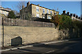
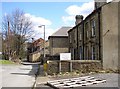
Retaining wall with blocked-up well, Elland Road, Brighouse
This is Ganny Well, as shown on old maps.
Image: © Humphrey Bolton
Taken: 29 Nov 2019
0.03 miles
6

Ganny Well, Elland Road, Brighouse
My guess is that this was a spring that opened up when the turnpike road was constructed, cutting into the hillside, in the early 19C. It would presumably have been used by passing horses, but might also have been the water supply for some of the many back-to-back houses that were on the south side of Elland Road. The opening has been walled-up very neatly, but the lintel and still can be seen.
Image: © Humphrey Bolton
Taken: 29 Nov 2019
0.03 miles
7
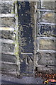
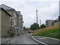
Benchmark on stone post in roadside wall of Halifax Road
Ordnance Survey cut mark benchmark described on the Bench Mark Database at www.bench-marks.org.uk
Image: © Roger Templeman
Taken: 31 Jul 2018
0.03 miles
8
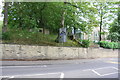
Stone wall on NE side of Halifax Road (A644)
There is an OS benchmark Image on the stone post in the wall at the wall junction right of the road direction sign
Image: © Roger Templeman
Taken: 31 Jul 2018
0.03 miles
9
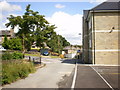
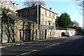
Empty Factory, Sunny Bank Road, Brighouse
Here a business has moved out of premises on an inconvenient site, which extends to the red-brick building in the distance, to a new business park. The houses in the foreground appear to have been used as offices, and the pallet is on the car park.
Image: © Humphrey Bolton
Taken: 10 Apr 2006
0.04 miles
10
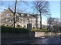
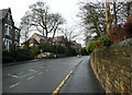
Knightsbridge Court, Brighouse
A block of flats seen from Halifax Road.
Image: © Humphrey Bolton
Taken: 17 Dec 2010
0.04 miles