IMAGES TAKEN NEAR TO
Old Lane Court, BRIGHOUSE, HD6 1UD
Introduction
This page details the photographs taken nearby to Old Lane Court, HD6 1UD by members of the Geograph project.
The Geograph project started in 2005 with the aim of publishing, organising and preserving representative images for every square kilometre of Great Britain, Ireland and the Isle of Man.

There are currently over 7.5m images from over14,400 individuals and you can help contribute to the project by visiting https://www.geograph.org.uk
Image Map
Images are licensed for reuse under creativecommons.org/licenses/by-sa/2.0
Notes
- Clicking on the map will re-center to the selected point.
- The higher the marker number, the further away the image location is from the centre of the postcode.
Image Listing (337 Images Found)
Images are licensed for reuse under creativecommons.org/licenses/by-sa/2.0
Image
Details
Distance
1
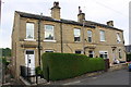
#2 Old Lane
There is an OS benchmark Image on the corner of the wall, left hand face, left of the path beside the house
Image: © Roger Templeman
Taken: 31 Jul 2018
0.03 miles
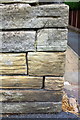
2
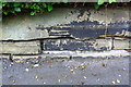
Benchmark on wall in front of #4 Old Lane
Ordnance Survey cut mark benchmark described on the Bench Mark Database at www.bench-marks.org.uk/bm49243
Image: © Roger Templeman
Taken: 27 Jul 2018
0.03 miles
3
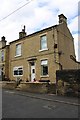
Nos. 6, 4 and 2 Old Lane
There is an OS benchmark Image on the wall under the hedge at the junction of No. 6 and 4
Image: © Roger Templeman
Taken: 27 Jul 2018
0.03 miles
6
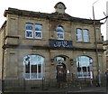
Brighouse District Industrial Society
Brighouse District Industrial Society Ltd Branch No15 1888
Image: © Alan Bate
Taken: 15 Jan 2016
0.04 miles
7
Benchmark on wall corner in front of #2 Old Lane
Ordnance Survey cut mark benchmark described on the Bench Mark Database at www.bench-marks.org.uk/bm49241
Image: © Roger Templeman
Taken: 31 Jul 2018
0.04 miles
8
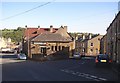
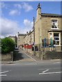
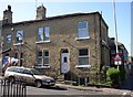
Barber Street and Thornhill Bridge Lane, Brighouse
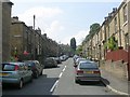
The short road on the right is Barber Street The houses are back-to-back with the ones on Firth Avenue. The rear of Thornhill Briggs Working Men's Club is in the centre of the photo. Thornhill Briggs is the name of the area near to what was Thornhill Bridge, but is now a ford.
Image: © Humphrey Bolton
Taken: 9 Oct 2006
0.04 miles
9
Loyal Peace Terrace, Oddfellows Street , off Bradford Road
The date on the plaque is 1888. The street name is another example of the Oddfellows Friendly Society being involved with house-building.
Image: © Humphrey Bolton
Taken: 30 Apr 2007
0.04 miles
10
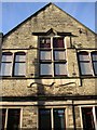
Detail of Thornhill Briggs Working Men's Club, Old Lane, Brighouse
A grand first-floor window, with the quirky styling of the early 20C. Must be after 1907 as the buildings shown on the map of that date are much smaller.
Image: © Humphrey Bolton
Taken: 30 Oct 2007
0.04 miles