1
Bonegate Road - viewed from Waterloo Road
Image: © Betty Longbottom
Taken: 27 Jun 2009
0.00 miles
2
Vacant land off Thornhill Bridge Lane, Brighouse
It seems strange that this land has never been built on. Old maps do not give a clue as they do not show a quarry or pit here.
Image: © Humphrey Bolton
Taken: 13 Apr 2020
0.02 miles
3
Benchmark on #30 Bonegate
Ordnance Survey cut mark benchmark described on the Bench Mark Database at www.bench-marks.org.uk/bm49244
Image: © Roger Templeman
Taken: 31 Jul 2018
0.02 miles
4
Nos. 30 and 28 Bonegate
There is an OS benchmark
Image on the road face of the left hand house, left of the white gate
Image: © Roger Templeman
Taken: 31 Jul 2018
0.02 miles
5
Garden between streets off Thornhill Bridge Lane, Brighouse
When I found this public garden between Firth Avenue and Vale Street I assumed that it had replaced a terrace of houses, but from old maps it seems that it has always been an open space.
Image: © Humphrey Bolton
Taken: 9 Oct 2006
0.03 miles
6
Firth Avenue, off Thornhill Bridge Lane, Brighouse
The 19C builders did not like to waste any space, and there are frequently odd-shaped houses at the end of terraces.
Image: © Humphrey Bolton
Taken: 9 Oct 2006
0.03 miles
7
Flats, Thornhill Bridge Lane, Brighouse
These are on the site of St Andrew's Church Schools, which had been built c.1884 and 1891 (Infants)..
Image: © Humphrey Bolton
Taken: 9 Oct 2006
0.03 miles
8
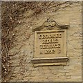
Datestone for Crooked Riding Terrace, Thornhills Bridge Lane, Brighouse
This is quite a large and elaborate datestone for a row of terrace houses, and has been placed on the blank gable-end. The houses face onto Anvil Street. Crooked Riding is the name of a house further down the street, although the second word is spelt Rhyding on one OS map and Ryding on another.
Image: © Humphrey Bolton
Taken: 26 Oct 2007
0.03 miles
9
Firth Avenue
See also closer shot of "street furniture"
Image
Image: © Tim Marchant
Taken: 24 Jul 2008
0.03 miles
10
Unconventional Street Furniture
Yes, it really is a rotary clothes line stuck in the road.
See also
Image
Image: © Tim Marchant
Taken: 24 Jul 2008
0.03 miles


