IMAGES TAKEN NEAR TO
Huntingdon Road, BRIGHOUSE, HD6 1PZ
Introduction
This page details the photographs taken nearby to Huntingdon Road, HD6 1PZ by members of the Geograph project.
The Geograph project started in 2005 with the aim of publishing, organising and preserving representative images for every square kilometre of Great Britain, Ireland and the Isle of Man.

There are currently over 7.5m images from over14,400 individuals and you can help contribute to the project by visiting https://www.geograph.org.uk
Image Map
Images are licensed for reuse under creativecommons.org/licenses/by-sa/2.0
Notes
- Clicking on the map will re-center to the selected point.
- The higher the marker number, the further away the image location is from the centre of the postcode.
Image Listing (68 Images Found)
Images are licensed for reuse under creativecommons.org/licenses/by-sa/2.0
Image
Details
Distance
1
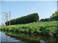
Tall hedge and strong fence
Northern bank of the River Calder, taken from a narrowboat.
Image: © Christine Johnstone
Taken: 22 May 2010
0.03 miles
2
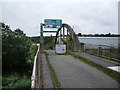
Footbridge over the River Calder, at the end of Huntingdon Road
Image: © Alexander P Kapp
Taken: 20 Oct 2008
0.03 miles

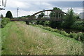
5
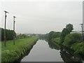
Green corridor
Tree-lined bank of the River Calder, with factories behind. taken from a narrowboat.
Image: © Christine Johnstone
Taken: 22 May 2010
0.04 miles
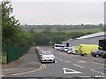
7
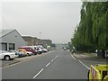
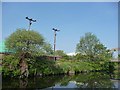
Armytage Road - viewed from Locksley Road
Image: © Betty Longbottom
Taken: 29 Jun 2009
0.04 miles
10
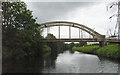
Bridge over River Calder
Calder and Hebble Canal - navigable River Calder section
Image: © Mike Todd
Taken: 18 Jun 2011
0.06 miles