IMAGES TAKEN NEAR TO
George Street, BRIGHOUSE, HD6 1PU
Introduction
This page details the photographs taken nearby to George Street, HD6 1PU by members of the Geograph project.
The Geograph project started in 2005 with the aim of publishing, organising and preserving representative images for every square kilometre of Great Britain, Ireland and the Isle of Man.

There are currently over 7.5m images from over14,400 individuals and you can help contribute to the project by visiting https://www.geograph.org.uk
Image Map
Images are licensed for reuse under creativecommons.org/licenses/by-sa/2.0
Notes
- Clicking on the map will re-center to the selected point.
- The higher the marker number, the further away the image location is from the centre of the postcode.
Image Listing (267 Images Found)
Images are licensed for reuse under creativecommons.org/licenses/by-sa/2.0
Image
Details
Distance
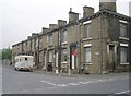
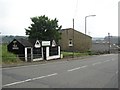
2
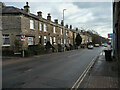
George Street in Brighouse
Looking south-westward from Wakefield Road (A644).
Image: © Peter Wood
Taken: 29 Aug 2017
0.00 miles
3
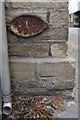
Houses of George Street at Wakefield Road junction
There is an OS benchmark Image on the corner, left hand face, of the nearest house.
Image: © Luke Shaw
Taken: 24 Jul 2018
0.01 miles
4
Alegar Street, Clifton
This short street connects the A643 from Leeds with the A644 from Dewsbury; it was originally a narrow cartway called Foddle lane. The present name is taken from a nearby well. Through traffic is banned to avoid motorists switching roads to try to jump the queue.
Image: © Humphrey Bolton
Taken: 12 Jun 2006
0.02 miles
5
Sandwich shop, Clifton Road, Clifton
An old-fashioned wooden hut.
Image: © Humphrey Bolton
Taken: 12 Jun 2006
0.02 miles
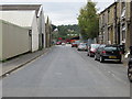
6
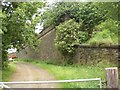
Station Road, Clifton
Now a private road. The line from Brighouse to Bradford was started in 1874 by the Lancashire and Yorkshire Railway Co. The line was not completed until 1881, and the Clifton Road station then opened. The station master kept hens under the arches on which the station was built. At one time up to twenty trains a day stopped at the station, but it was closed in 1931 and demolished in 1934. The line had been closed by 1953.
Image: © Humphrey Bolton
Taken: 12 Jun 2006
0.02 miles
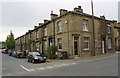
7
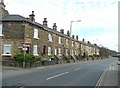
Terrace houses, Wakefield Road (A644), Clifton
These extend eastwards from the foot of Alegar Street, past the site of a tollbar for the former turnpike road , the Brighouse and Elland Trust.
Image: © Humphrey Bolton
Taken: 16 Mar 2009
0.02 miles
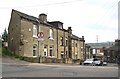
8
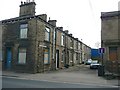
Blackburn Buildings, Clifton
Two rows of back-to-back houses, one facing Wakefield Road and one facing George Street, with the back houses all facing a yard, the entrance to which is shown here.
Image: © Humphrey Bolton
Taken: 16 Mar 2009
0.02 miles
10
Terrace houses, Wakefield Road, Brighouse
This is an update on Image taken in 2009. Not much has changed, but an evergreen tree has appeared.
Image: © Humphrey Bolton
Taken: 5 Jan 2021
0.03 miles