IMAGES TAKEN NEAR TO
Mill Lane, BRIGHOUSE, HD6 1PQ
Introduction
This page details the photographs taken nearby to Mill Lane, HD6 1PQ by members of the Geograph project.
The Geograph project started in 2005 with the aim of publishing, organising and preserving representative images for every square kilometre of Great Britain, Ireland and the Isle of Man.

There are currently over 7.5m images from over14,400 individuals and you can help contribute to the project by visiting https://www.geograph.org.uk
Image Map
Images are licensed for reuse under creativecommons.org/licenses/by-sa/2.0
Notes
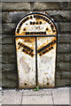
- Clicking on the map will re-center to the selected point.
- The higher the marker number, the further away the image location is from the centre of the postcode.
Image Listing (915 Images Found)
Images are licensed for reuse under creativecommons.org/licenses/by-sa/2.0
Image
Details
Distance
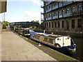
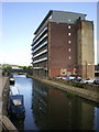
2
Calder & Hebble Navigation
Between Mill Royd Mill and Sainsbury's
Image: © Alexander P Kapp
Taken: 15 Jul 2009
0.01 miles
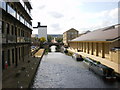
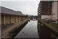
3
Calder & Hebble Navigation North Cut
The building on the right hand side of the canal is Sainsbury's on the site of Victoria Mills
Image: © Roger Templeman
Taken: 18 Jul 2018
0.01 miles
4
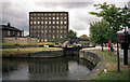
Brighouse Upper Lock, Calder and Hebble Navigation
Image: © Dr Neil Clifton
Taken: 25 Jul 1996
0.02 miles
5
Calder & Hebble Navigation
With Mill Royd Mill
Image: © Alexander P Kapp
Taken: 15 Jul 2009
0.02 miles
7
Mill Lane and the Barge Inn, Brighouse
Mill Lane leads to the industrial estate on Clifton Ings. The Barge Inn is handy for the canal basin, which is on the right a short way up the road.
Image: © Humphrey Bolton
Taken: 7 Aug 2006
0.02 miles
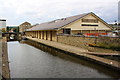
8
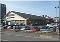
Sainsbury's supermarket , Brighouse
Somewhat upstaged by the Tesco store nearby.
Image: © Humphrey Bolton
Taken: 18 Mar 2009
0.02 miles
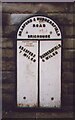
9
Metal milepost set in Huddersfield Road wall
Image: © Roger Templeman
Taken: 18 Jul 2018
0.03 miles
10
Old Milestone, on the A641, Huddersfield Road
On boundary wall of Sainsbury's Supermarket (N of canal bridge). Located on the East side of road, bolted to wall. Metal plate detached from post, Brayshaw & Booth casting design, 19th century. Alternative views see http://www.geograph.org.uk/photo/6740925 & http://www.geograph.org.uk/photo/563416
Inscription reads: lhs-BRADFORD / 7 MILES rhs-HUDDERSFIELD / 4 MILES // BRADFORD & HUDDERSFIELD / ROAD / BRIGHOUSE // BRAYSHAW & BOOTH / MAKERS / LIVERSEDGE
Grade II listed by Historic England. see https://historicengland.org.uk/listing/the-list/list-entry/1314037
Milestone Society National ID: YW_HUBF04
Image: © Christine Minto
Taken: 21 Dec 2005
0.03 miles