IMAGES TAKEN NEAR TO
Birds Royd Lane, BRIGHOUSE, HD6 1NG
Introduction
This page details the photographs taken nearby to Birds Royd Lane, HD6 1NG by members of the Geograph project.
The Geograph project started in 2005 with the aim of publishing, organising and preserving representative images for every square kilometre of Great Britain, Ireland and the Isle of Man.

There are currently over 7.5m images from over14,400 individuals and you can help contribute to the project by visiting https://www.geograph.org.uk
Image Map
Images are licensed for reuse under creativecommons.org/licenses/by-sa/2.0
Notes
- Clicking on the map will re-center to the selected point.
- The higher the marker number, the further away the image location is from the centre of the postcode.
Image Listing (106 Images Found)
Images are licensed for reuse under creativecommons.org/licenses/by-sa/2.0
Image
Details
Distance
1
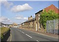
River Street, Birds Royd, Rastrick
Rather a cheerless street, set out by c.1895 but not fully developed until the second half of the 20C. The 19C buildings have generally been replaced by modern ones.
Image: © Humphrey Bolton
Taken: 8 Apr 2006
0.02 miles
2
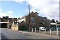
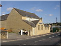
Former Wesleyan Chapel, Mission Street, Birds Royd, Rastrick
The Wesleyan Mission Chapel was built in 1898 and rebuilt in 1904. It is now an office building. A Sunday School was added opposite the chapel in 1916, but this has gone.
Image: © Humphrey Bolton
Taken: 8 Apr 2006
0.02 miles
3
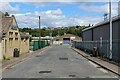
Mission Street, Brighouse
Short street in a mainly industrial estate on the eastern side of Brighouse
Image: © Chris Heaton
Taken: 29 May 2022
0.03 miles
5
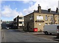
Birds Royd Lane, Rastrick
This area is gradually being redeveloped with large modern industrial sheds, but some old buildings remain.
Image: © Humphrey Bolton
Taken: 12 Sep 2007
0.05 miles
6
Former Methodist Chapel, Mission Street, Rastrick
The Wesleyan Mission Chapel was built in 1898 and rebuilt in 1904. It is now an office building. A Sunday School was added opposite the chapel in 1916, but this has gone.
Image: © Humphrey Bolton
Taken: 12 Sep 2007
0.05 miles
7
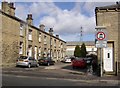
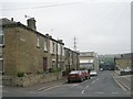
Providence Place, Birds Royd, Rastrick
Two rows of workers' houses, built by c.1895, probably by the owner of one of the nearby factories. The name is carved in stone on the end houses. There must be a good reason for the road sign; perhaps the street was used as a short cut to the factory yard at the end.
Image: © Humphrey Bolton
Taken: 8 Apr 2006
0.05 miles
8
Calder Street, Birds Royd, Rastrick
The Woodlands was built by c.1895, but the Victoria Works behind now has a modern office block.
Image: © Humphrey Bolton
Taken: 8 Apr 2006
0.05 miles
10
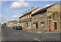
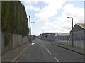
Birds Royd Lane, Rastrick
The view from the junction with Mission Street (named after the Wesleyan mission chapel). Although this is an industrial area, there are a number of 19C terrace houses here and there.
Image: © Humphrey Bolton
Taken: 12 Sep 2007
0.07 miles